
Lake Mead is at about 150 feet above “Dead Pool”. That is the point where you can’t get the water to flow past the dam as the intake is above the water surface.
Even before that it stops generating electrical power. Already the production is cut to just 5 turbines producing power for cities, from the total of 19 turbines (though it is important to note that 2 of the 19 are used just for power to run the dam complex itself).
https://en.wikipedia.org/wiki/Hoover_Dam
Note that the 2 Pelton Type are used to power the dam itself.
Turbines
13 × 130 MW
2 × 127 MW
1 × 68.5 MW
1 × 61.5 MW Francis-type
2 × 2.4 MW Pelton-type
[…]
Before water from Lake Mead reaches the turbines, it enters the intake towers and then four gradually narrowing penstocks which funnel the water down towards the powerhouse. The intakes provide a maximum hydraulic head (water pressure) of 590 ft (180 m) as the water reaches a speed of about 85 mph (140 km/h). The entire flow of the Colorado River usually passes through the turbines. The spillways and outlet works (jet-flow gates) are rarely used. The jet-flow gates, located in concrete structures 180 feet (55 m) above the river and also at the outlets of the inner diversion tunnels at river level, may be used to divert water around the dam in emergency or flood conditions, but have never done so, and in practice are used only to drain water from the penstocks for maintenance. Following an uprating project from 1986 to 1993, the total gross power rating for the plant, including two 2.4 megawatt Pelton turbine-generators that power Hoover Dam’s own operations is a maximum capacity of 2080 megawatts. The annual generation of Hoover Dam varies. The maximum net generation was 10.348 TWh in 1984, and the minimum since 1940 was 2.648 TWh in 1956. The average power generated was 4.2 TWh/year for 1947–2008. In 2015, the dam generated 3.6 TWh.
The amount of electricity generated by Hoover Dam has been decreasing along with the falling water level in Lake Mead due to the prolonged drought since year 2000 and high demand for the Colorado River’s water. By 2014 its generating capacity was downrated by 23% to 1592 MW and was providing power only during periods of peak demand. Lake Mead fell to a new record low elevation of 1,071.61 feet (326.63 m) on July 1, 2016, before beginning to rebound slowly. Under its original design, the dam would no longer be able to generate power once the water level fell below 1,050 feet (320 m), which might have occurred in 2017 had water restrictions not been enforced. To lower the minimum power pool elevation from 1,050 to 950 feet (320 to 290 m), five wide-head turbines, designed to work efficiently with less flow, were installed.
So peak was over 10k TWhr and we ran 3.6k TWhr in 2015, but now we are running even less. OK…
Who gets this power (and water…)?
Area Percentage
Metropolitan Water District of Southern California 28.53%
State of Nevada 23.37%
State of Arizona 18.95%
Los Angeles, California 15.42%
Southern California Edison 5.54%
Boulder City, Nevada 1.77%
Glendale, California 1.59%
Pasadena, California 1.36%
Anaheim, California 1.15%
Riverside, California 0.86%
Vernon, California 0.62%
Burbank, California 0.59%
Azusa, California 0.11%
Colton, California 0.09%
Banning, California 0.05%
You can also think of this as the “who gets screwed when it runs dry” list.
Note that all those little California cities at the end of the list are part of the greater Los Angeles Basin. Basically, it’s the growth areas of Phoenix and related in Arizona, Las Vegas Nevada area, and a big chunk of Southern California.
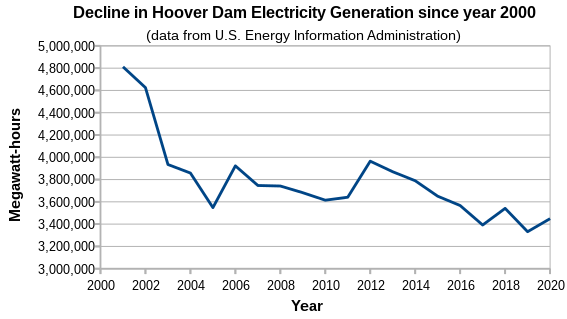
Here’s what’s been happening over the recent years:
From: https://en.wikipedia.org/wiki/File:Hoover_dam_electricity_generation_since_2000.svg
As water levels drop, you get ever less production. We’re much lower than the end of that graph now.
https://www.esquire.com/news-politics/politics/a40436565/lake-mead-water-level-dead-pool/
The title of the Esquire article refers to the metal barrels dumped in the lake, supposedly by Mafia from Las Vegas, found with bones / bodies in them as the lake dried up. I like his turn of phrase about “Chinese climate hoaxsters” ;-)
Lake Mead Could Soon Be a ‘Dead Pool.’ It’s Already a Pool of the Dead.
The reservoir, which provides water to huge swathes of the American West, is drying up.By Charles P. Pierce
Jun 27, 2022As democracy grows more desiccated in Washington, elsewhere in the country, where those crafty Chinese climate hoaxsters continue to ply their shenanigans, the talk of something dying of thirst is far less metaphorical. From NBC News:
Lake Mead’s water level on Wednesday was measured at 1,044.03 feet, its lowest elevation since the lake was filled in the 1930s. If the reservoir dips below 895 feet — a possibility still years away — Lake Mead would reach dead pool, carrying enormous consequences for millions of people across Arizona, California, Nevada and parts of Mexico. “This is deadly serious stuff,” said Robert Glennon, an emeritus professor at the University of Arizona who specializes in water law and policy.
Persistent drought conditions over the past two decades, exacerbated by climate change and increased water demands across the southwestern United States, have contributed to Lake Mead’s depletion. Though the reservoir is at risk of becoming a dead pool, it would most likely take several more years to reach that level, Glennon said.
One problem piles on another. The federal Bureau of Reclamation is trying to fill up Lake Mead—and Lake Powell—again, but to do so, it has to regulate the use of the Colorado River by several western states.
Dead pool would not mean that there was no water left in the reservoir, but even before Lake Mead were to hit that point, there are concerns that water levels could fall so low that the production of hydroelectric power would be hindered.
“Electricity generation in our western reservoirs becomes a problem as the water level in the reservoirs goes down,” Glennon said. As a reservoir is depleted, there is less water flowing through turbines and less liquid pressure to make them spin, which means the turbines produce less electricity, he added.
So we’ve got a double trouble thing going on here. Less electricity being made just as the big push for Electric Cars is coming on, and water about to be restricted (even more than it already has been for several years…).
They say it is “several years” away from running dry, but that depends on some assumptions. That folks DO cut back water use (from fairly little to even less), that Agriculture (THE biggest user at 80-85%) is willing to grow less, and that rains return to near average or above. Facts not in evidence…
There are some places I’d gladly see more conservation, or even outright banning of use: Like those places growing water intensive alfalfa that is shipped to Saudi Arabia to feed their race horses… But a lot of the water is used to grow the nations fruits, nuts, and vegetables in California and Arizona. Cut water, eat less. Decisions decisions…
Then we’ve got about 1045 feet down to 895 feet (above sea level) before the Colorado River dries up. Call it 150 feet. BUT, the lake is in a narrow V shaped valley. The lower it goes the faster it goes lower as there is ever less water per foot of height. Right now it is dropping about 8 inches (or 2/3 of a foot) per day. Now I know it doesn’t stay constant, but at this rate it would be about 150 x 3/2 = 225 days to Dead Pool. Add in a weak water year and you are looking at about September 2023.
Things that mitigate:
There’s a bunch of dams up stream from Lake Mead / Hoover Dam. They can release more water if needed (but some of them are in distress too.) Oh, and this would require The Government to manage those water releases honestly, fairly, and appropriately. Uh Huh…
We could get an excess rain year. (OTOH, it took several rainy years to originally fill the lake…)
Folks could conserve a whole lot (yeah, right /sark;)
The rampant over building of houses in Arizona, Nevada, and California could stop. (Tell me another one! /snark;)
So what I expect will happen is that the present “over draft” of Colorado river water will continue and accelerate despite efforts to stop it, and farmers will continue to grow water wasting crops like Alfalfa, cotton, almonds, and more in the desert. Right down to where the lakes run dry and water and power get shut off for a little while.
Many articles about this tack on “Climate Change” right after they say “over use of water”. Folks, it’s the over development and over use of water that’s the real problem. California has grown to about 6 x the population during the life of Hoover Dam / Lake Mead as has Phoenix, Las Vegas, et. al. Just too many folks sucking on the same old water pipe. Building right up to the limit capacity in a wet few years, so zero headroom for dry years (or even average years, really). (California was about 6 million in the 1930’s when the dam was built, almost 40 million now).
The biggest lake up stream of Lake Mead, is Lake Powell. It, too, is running dry. It is presently about 35 feet above the point where electric generation stops. But there are some dams / lakes above it that can be drained to keep it going for a while. Here’s a map of what all dams / reservoirs are in the Colorado Drainage Basin:
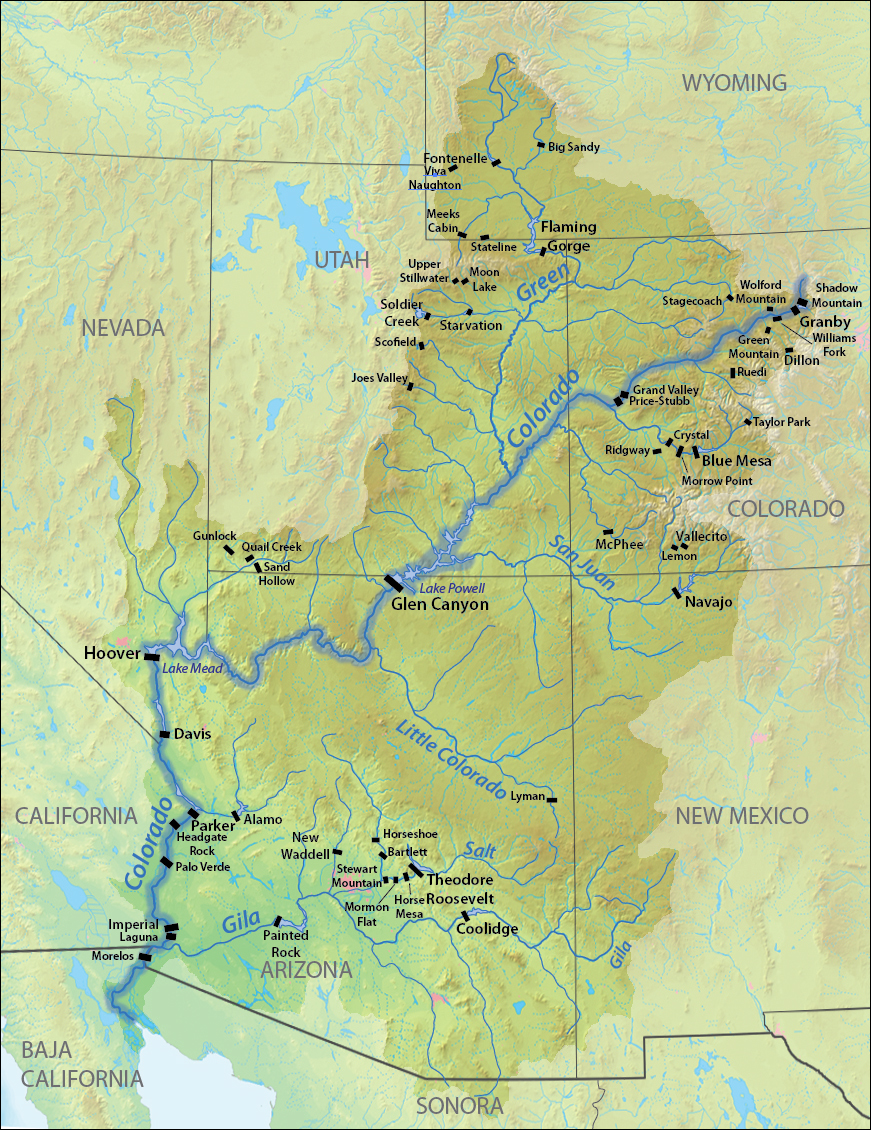
From: https://en.wikipedia.org/wiki/List_of_dams_in_the_Colorado_River_system
Unfortunately, all of the others are much much smaller than Lake Powell or Lake Mead, so at best are a short term stop-gap before running dry. Most of them are in the “hundreds of thousands” (of acre feet – water to cover one acre one foot deep) while Powell & Mead are in the 26 & 28 Million acre-feet range. (Only Davis dam gets to 1.8 Million acre-feet and it is below lake Mead… so doesn’t help Powell or Mead).
https://www.desertusa.com/riverinfo/c_river.html
https://www.usbr.gov/newsroom/#/news-release/4196
Reclamation’s drought response actions will boost Lake Powell
Additional water will help protect Glen Canyon Dam operations in 2022
[…]
SALT LAKE CITY – The Bureau of Reclamation today announced two separate urgent drought response actions that will help prop up Lake Powell by nearly 1 million acre-feet (maf) of water over the next 12 months (May 2022 through April 2023). Today, Lake Powell’s water surface elevation is at 3,522 feet, its lowest level since originally being filled in the 1960s. A critical elevation at Lake Powell is 3,490 feet, the lowest point at which Glen Canyon Dam can generate hydropower. This elevation introduces new uncertainties for reservoir operations and water deliveries because the facility has never operated under such conditions for an extended period. These two actions equate to approximately 16 feet of elevation increase.Given the extraordinary circumstances in the Basin, Reclamation is invoking its authority to change annual operations at Glen Canyon Dam for the first time. The measure protects hydropower generation, the facility’s key infrastructure, and the water supply for the city of Page, Arizona, and the LeChee Chapter of the Navajo Nation.
[…]
To protect Lake Powell, more water will flow into the lake from upstream reservoirs and less water will be released downstream:Under a Drought Contingency Plan adopted in 2019, approximately 500 thousand acre-feet (kaf) of water will come from Flaming Gorge Reservoir, located approximately 455 river miles upstream of Lake Powell.
Another 480 kaf will be left in Lake Powell by reducing Glen Canyon Dam’s annual release volume from 7.48 maf to 7.0 maf, as outlined in the 2007 Interim Guidelines that control operations of Glen Canyon Dam and Hoover Dam.
Good for Lake Powell as it takes it from the danger zone on electric generation to a bit above, but bad for Lake Mead as there will be less flowing into it and it already isn’t getting enough.
In “The sNews”, you will hear great pronouncements of how Horrible and Extreme!!! the Drought Of All Ages has been!!!!… but is it really?
Here’s a PDF with a nice map in it with lots of green normal and limited yellow somewhat low:
https://www.wcc.nrcs.usda.gov/ftpref/data/water/wcs/gis/maps/west_wytdprecpctnormal_update.pdf
And a screen shot of it:

Colorado River Basin Precip July 2022
So yeah, some drought, but that ought to be livable if not overbuilt / overdrawing on the lakes.
Then some lists of data (scroll right to see summary percentages):
https://wcc.sc.egov.usda.gov/reports/UpdateReport.html?report=Upper%20Colorado%20River%20Basin
I see an awful lot of 98%, 102% 89% etc. in the far right column (scroll over) and not a lot of horrible shortfall basin wide…
Upper Colorado River Basin
SNOTEL Snow/Precipitation Update Report
Based on Mountain Data from NRCS SNOTEL Sites
**Provisional data, subject to revision**
Data based on the first reading of the day (typically 00:00) for Monday, July 04, 2022
Basin
  Site Name	Elev
(ft)	Snow Water Equivalent	Water Year-to-Date Precipitation
Current
(in)	Median
(in)	Pct of
Median	Current
(in)	Median
(in)	Pct of
Median
UPPER GREEN RIVER BASIN
  Big Sandy Opening	9080	0.0   	0.0   	*  	17.9   	19.3   	93
  Blacks Fork Jct	8869	0.4   	0.0(10)	*  	18.6   	16.6(10)	112
  Blind Bull Sum	8650	-M   	0.0   	*  	20.1   	25.1   	80
  Buck Pasture	9632	0.0   	N/A   	*  	25.0   	N/A   	*
  East Rim Divide	7930	0.0   	0.0   	*  	15.1   	16.6   	91
  EF Blacks Fork GS	9360	0.0   	0.0(10)	*  	22.3   	18.1(10)	123
  Elkhart Park G.S.	9400	0.1   	0.0   	*  	14.9   	19.6   	76
  Gros Ventre Summit	8750	1.3   	0.0   	*  	17.2   	18.6   	92
  Gunsight Pass	9820	0.1   	0.0(22)	*  	20.8   	20.4(22)	102
  Hams Fork	7840	0.0   	0.0   	*  	15.0   	17.2   	87
  Hewinta	9500	0.0   	0.0   	*  	22.5   	20.4   	110
  Hickerson Park	9122	0.0   	0.0   	*  	17.6   	16.0   	110
  Hole-in-Rock	9168	0.0   	0.0   	*  	17.8   	16.0   	111
  Indian Creek	9425	0.0   	0.0   	*  	25.6   	27.8   	92
  Kelley R.S.	8180	-M   	0.0   	*  	21.6   	24.6   	88
  Kendall R.S.	7740	0.0   	0.0   	*  	18.7   	18.6   	101
  Kings Cabin	8728	0.4   	0.0   	*  	21.8   	17.9   	122
  Loomis Park	8240	0.0   	0.0   	*  	20.8   	23.6   	88
  New Fork Lake	8340	0.0   	0.0   	*  	14.1   	16.8   	84
  Pocket Creek	9360	-M   	N/A   	*  	-M   	N/A   	*
  Snider Basin	8060	0.0   	0.0   	*  	19.9   	19.6   	102
  Spirit Lk	10235	0.1   	0.0(11)	*  	24.0   	22.7(11)	106
  Spring Creek Divide	9000	0.0   	0.0   	*  	30.1   	31.8   	95
  Steel Creek Park	10158	0.0   	0.0   	*  	26.1   	23.7   	110
  Triple Peak	8500	-M   	0.0   	*  	34.1   	35.6   	96
  Trout Creek	9518	0.1   	0.0   	*  	19.0   	18.8   	101
Basin Index (%)	*  	98
DUCHESNE RIVER BASIN
  Brown Duck	10574	0.0   	0.0   	*  	24.0   	23.8   	101
  Chepeta	10499	-M   	0.0   	*  	21.9   	20.4   	107
  Currant Creek	7915	0.4   	0.0   	*  	15.7   	15.8   	99
  Daniels-Strawberry	8008	0.0   	0.0   	*  	21.7   	22.0   	99
  Five Points Lake	10943	0.5   	0.0   	*  	24.1   	24.8   	97
  Indian Canyon	9171	0.0   	0.0   	*  	18.9   	17.7   	107
  Kings Cabin	8728	0.4   	0.0   	*  	21.8   	17.9   	122
  Lakefork #1	10128	0.0   	0.0   	*  	19.7   	18.0   	109
  Lakefork #3	8464	0.0   	0.0(11)	*  	16.8   	13.4(11)	125
  Lakefork Basin	10885	0.0   	0.0   	*  	28.3   	28.2   	100
  Mosby Mtn.	9553	0.1   	0.0   	*  	20.0   	19.1   	105
  Rock Creek	7886	0.1   	0.0   	*  	15.1   	14.6   	103
  Strawberry Divide	8123	0.0   	0.0   	*  	20.5   	20.9   	98
  Trial Lake	9992	0.0   	0.0   	*  	29.3   	29.8   	98
  White River #1	8641	0.0   	0.0   	*  	18.2   	17.2   	106
Basin Index (%)	*  	104
YAMPA/WHITE RIVER BASINS
  Battle Mountain	7498	0.0   	0.0   	*  	21.0   	20.5   	102
  Bear River	9112	0.1   	0.0(16)	*  	17.6   	18.5(16)	95
  Bison Lake	10964	-M   	0.0   	*  	35.0   	33.6   	104
  Buffalo Park	9249	0.0   	0.0(25)	*  	19.8   	21.8(25)	91
  Burro Mountain	9317	-M   	0.0   	*  	-M   	27.2   	*
  Columbine	9167	0.0   	0.0   	*  	32.7   	33.4   	98
  Crosho	8973	0.0   	0.0   	*  	23.4   	21.4   	109
  Divide Peak	8730	0.0   	0.0   	*  	26.3   	28.6   	92
  Dry Lake	8271	0.2   	0.0   	*  	33.2   	34.0   	98
  Elk River	8739	0.0   	0.0   	*  	28.9   	26.2   	110
  Little Snake River	8928	0.0   	0.0(16)	*  	39.4   	42.8(16)	92
  Lost Dog	9327	0.8   	0.0(22)	*  	29.5   	32.4(22)	91
  Lynx Pass	8919	0.0   	0.0   	*  	15.8   	18.2   	87
  Old Battle	9860	0.1   	0.0   	*  	40.0   	45.6   	88
  Rabbit Ears	9411	0.0   	0.0   	*  	41.4   	40.8   	101
  Ripple Creek	10350	0.0   	0.0   	*  	32.4   	33.8   	96
  Sage Creek Basin	7850	-M   	0.0(19)	*  	15.3   	17.6(19)	87
  Sandstone RS	8152	0.0   	0.0   	*  	21.4   	23.3   	92
  Tower	10620	-M   	0.0   	*  	54.1   	53.8   	101
  Trapper Lake	9759	-M   	N/A   	*  	23.0   	27.0   	85
  Whiskey Park	9020	0.0   	0.0   	*  	37.8   	37.8   	100
Basin Index (%)	*  	96
PRICE-SAN RAFAEL
  Buck Flat	9409	0.0   	0.0   	*  	22.8   	22.6   	101
  Clear Creek #1	8975	0.1   	0.0   	*  	23.5   	26.4   	89
  Corral	8207	0.0   	N/A   	*  	17.1   	N/A   	*
  Huntington Horse	9652	-M   	N/A   	*  	25.2   	N/A   	*
  Mammoth-Cottonwood	8709	0.0   	0.0   	*  	22.6   	20.1   	112
  Red Pine Ridge	8988	0.2   	0.0   	*  	24.4   	23.4   	104
  Seeley Creek	9904	-M   	0.0   	*  	16.7   	17.6   	95
  Timberline	8736	0.0   	0.0(13)	*  	19.4   	17.9(13)	108
  Upper Joes Valley	8596	0.0   	N/A   	*  	17.6   	N/A   	*
  White River #1	8641	0.0   	0.0   	*  	18.2   	17.2   	106
  Wrigley Creek	9327	0.0   	N/A   	*  	17.4   	N/A   	*
Basin Index (%)	*  	102
ESCALANTE RIVER BASINS
  Clayton Springs	10049	0.1   	0.0(21)	*  	-M   	18.0(20)	*
  Donkey Reservoir	9799	-M   	0.0   	*  	9.4   	13.5   	70
  Sunflower Flat	10018	0.0   	N/A   	*  	13.8   	N/A   	*
  Widtsoe #3	9640	0.6   	0.0   	*  	12.7   	18.0   	71
Basin Index (%)	*  	70
DIRTY DEVIL RIVER BASIN
  Black Flat-U.M. Ck	9414	0.1   	0.0   	*  	12.8   	15.3   	84
  Dills Camp	9228	0.0   	0.0   	*  	20.8   	21.5   	97
  Donkey Reservoir	9799	-M   	0.0   	*  	9.4   	13.5   	70
  Fish Lake Utah	8798	0.4   	0.0(10)	*  	10.9   	10.1(10)	108
  Lonesome Beaver	9410	0.0   	N/A   	*  	13.6   	N/A   	*
  Sunflower Flat	10018	0.0   	N/A   	*  	13.8   	N/A   	*
Basin Index (%)	*  	89
UPPER COLORADO RIVER HEADWATERS
  Arapaho Ridge	10976	0.0   	0.0(18)	*  	29.7   	31.0(18)	96
  Beaver Ck Village	8565	0.1   	0.0(17)	*  	20.0   	19.3(17)	104
  Berthoud Summit	11314	0.3   	0.0   	*  	32.5   	33.9   	96
  Bison Lake	10964	-M   	0.0   	*  	35.0   	33.6   	104
  Buffalo Park	9249	0.0   	0.0(25)	*  	19.8   	21.8(25)	91
  Columbine	9167	0.0   	0.0   	*  	32.7   	33.4   	98
  Copper Mountain	10523	-M   	0.0   	*  	-M   	23.3   	*
  Elliot Ridge	10549	0.1   	0.0(11)	*  	-M   	N/A   	*
  Fool Creek	11156	0.1   	N/A   	*  	25.1   	N/A   	*
  Fremont Pass	11326	-M   	0.0   	*  	-M   	22.7   	*
  Grizzly Peak	11139	0.1   	0.0   	*  	22.5   	25.2   	89
  High Lonesome	10638	-M   	N/A   	*  	-M   	N/A   	*
  Hoosier Pass	11611	0.1   	0.0   	*  	-M   	22.4   	*
  Lake Irene	10682	0.8   	0.0   	*  	31.0   	29.0   	107
  Lynx Pass	8919	0.0   	0.0   	*  	15.8   	18.2   	87
  Phantom Valley	9045	0.0   	0.0   	*  	18.1   	19.5   	93
  Stillwater Creek	8880	0.0   	N/A   	*  	15.4   	15.2   	101
  Summit Ranch	9371	0.1   	0.0   	*  	19.3   	19.4   	99
  Vail Mountain	10310	0.1   	0.0   	*  	22.4   	28.8   	78
  Willow Creek Pass	9523	-M   	0.0   	*  	22.0   	21.6   	102
Basin Index (%)	*  	96
ROARING FORK RIVER BASIN
  Chapman Tunnel	10100	0.0   	0.0(13)	*  	24.2   	25.1(13)	96
  Independence Pass	10598	-M   	0.0   	*  	21.1   	23.9   	88
  Ivanhoe	10541	-M   	0.0(29)	*  	27.4   	29.4(29)	93
  Kiln	9624	0.0   	0.0   	*  	18.8   	19.4   	97
  Mc Clure Pass	8774	0.1   	0.0   	*  	22.8   	25.3   	90
  Nast Lake	8731	0.2   	0.0   	*  	16.6   	16.4   	101
  North Lost Trail	9219	0.1   	0.0   	*  	28.2   	27.6   	102
  Schofield Pass	10653	0.0   	0.0   	*  	44.6   	38.4   	116
Basin Index (%)	*  	99
SOUTH EASTERN UTAH
  Buckboard Flat	8924	0.8   	N/A   	*  	18.6   	N/A   	*
  Camp Jackson	8858	0.0   	0.0   	*  	14.3   	21.0   	68
  East Willow Creek	8302	0.0   	0.0   	*  	13.3   	14.8   	90
  Lasal Mountain	9578	0.0   	0.0   	*  	22.9   	23.2   	99
  Lasal Mountain-Lower	8783	-M   	N/A   	*  	14.3   	N/A   	*
  Lonesome Beaver	9410	0.0   	N/A   	*  	13.6   	N/A   	*
Basin Index (%)	*  	86
GUNNISON RIVER BASIN
  Butte	10200	0.0   	0.0   	*  	18.1   	19.4   	93
  Cochetopa Pass	10061	0.0   	0.0(16)	*  	11.7   	10.6(16)	110
  Columbine Pass	9171	0.0   	0.0   	*  	29.2   	27.6   	106
  Idarado	9812	0.2   	0.0   	*  	20.6   	24.6   	84
  Mc Clure Pass	8774	0.1   	0.0   	*  	22.8   	25.3   	90
  Mesa Lakes	10168	0.0   	0.0   	*  	26.3   	27.1   	97
  Overland Res.	9893	0.0   	0.0   	*  	20.0   	21.2   	94
  Park Cone	9621	0.0   	0.0   	*  	17.1   	14.8   	116
  Park Reservoir	9987	0.4   	0.0   	*  	34.9   	32.0   	109
  Porphyry Creek	10788	0.0   	0.0   	*  	24.1   	20.6   	117
  Red Mountain Pass	11080	0.1   	0.0   	*  	28.7   	32.5   	88
  Sargents Mesa	11499	0.0   	0.0(12)	*  	13.1   	16.2(12)	81
  Schofield Pass	10653	0.0   	0.0   	*  	44.6   	38.4   	116
  Slumgullion	11560	0.0   	0.0   	*  	15.7   	17.8   	88
  Upper Taylor	10717	0.0   	0.0(11)	*  	26.1   	23.8(11)	110
  Wager Gulch	11132	0.1   	N/A   	*  	15.3   	N/A   	*
Basin Index (%)	*  	100
DOLORES/SAN MIGUEL RIVER BASINS
  Black Mesa	11564	0.1   	N/A   	*  	27.7   	N/A   	*
  El Diente Peak	10217	0.1   	0.0   	*  	21.0   	25.4   	83
  Lizard Head Pass	10193	0.0   	0.0   	*  	18.2   	21.1   	86
  Lone Cone	9755	0.0   	0.0   	*  	19.6   	24.6   	80
  Mancos	10044	0.0   	0.0(26)	*  	15.9   	21.7(26)	73
  Mineral Creek	10046	0.1   	0.0   	*  	22.0   	22.6   	97
  Red Mountain Pass	11080	0.1   	0.0   	*  	28.7   	32.5   	88
  Scotch Creek	9195	0.0   	0.0   	*  	19.3   	21.5   	90
  Sharkstooth	10747	0.0   	0.0(16)	*  	27.9   	28.2(16)	99
Basin Index (%)	*  	87
SAN JUAN RIVER HEADWATERS
  Beartown	11600	-M   	0.0   	*  	28.0   	30.0   	93
  Chamita	8383	0.0   	0.0   	*  	17.5   	15.6   	112
  Lily Pond	11069	0.1   	0.0   	*  	23.8   	23.6   	101
  Middle Creek	11269	0.0   	0.0   	*  	28.1   	27.6   	102
  Stump Lakes	11248	0.1   	0.0   	*  	22.9   	25.4   	90
  Upper San Juan	10140	-M   	0.0   	*  	38.2   	39.7   	96
  Vallecito	10782	0.0   	0.0   	*  	22.3   	23.2   	96
  Weminuche Creek	10749	0.0   	0.0(10)	*  	25.4   	25.8(10)	98
  Wolf Creek Summit	10957	0.0   	0.0   	*  	37.5   	39.5   	95
Basin Index (%)	*  	97
ANIMAS RIVER BASIN
  Beartown	11600	-M   	0.0   	*  	28.0   	30.0   	93
  Cascade	8880	0.0   	0.0   	*  	22.4   	24.1   	93
  Cascade #2	9012	0.0   	0.0   	*  	22.6   	22.6   	100
  Columbus Basin	10781	0.0   	0.0(26)	*  	28.6   	32.4(26)	88
  Mineral Creek	10046	0.1   	0.0   	*  	22.0   	22.6   	97
  Molas Lake	10631	-M   	0.0   	*  	25.7   	25.1   	102
  Red Mountain Pass	11080	0.1   	0.0   	*  	28.7   	32.5   	88
  Spud Mountain	10674	0.0   	0.0   	*  	34.7   	35.8   	97
  Stump Lakes	11248	0.1   	0.0   	*  	22.9   	25.4   	90
Basin Index (%)	*  	94
COLORADO RIVER BASIN ABOVE LAKE POWELL (TOTAL OF ALL SNOTEL SITES)
  Beartown	11600	-M   	0.0   	*  	28.0   	30.0   	93
  Black Mesa	11564	0.1   	N/A   	*  	27.7   	N/A   	*
  Slumgullion	11560	0.0   	0.0   	*  	15.7   	17.8   	88
  Sargents Mesa	11499	0.0   	0.0(12)	*  	13.1   	16.2(12)	81
  Hoosier Pass	11611	0.1   	0.0   	*  	-M   	22.4   	*
  Fremont Pass	11326	-M   	0.0   	*  	-M   	22.7   	*
  Berthoud Summit	11314	0.3   	0.0   	*  	32.5   	33.9   	96
  Middle Creek	11269	0.0   	0.0   	*  	28.1   	27.6   	102
  Stump Lakes	11248	0.1   	0.0   	*  	22.9   	25.4   	90
  Red Mountain Pass	11080	0.1   	0.0   	*  	28.7   	32.5   	88
  Fool Creek	11156	0.1   	N/A   	*  	25.1   	N/A   	*
  Wager Gulch	11132	0.1   	N/A   	*  	15.3   	N/A   	*
  Grizzly Peak	11139	0.1   	0.0   	*  	22.5   	25.2   	89
  Wolf Creek Summit	10957	0.0   	0.0   	*  	37.5   	39.5   	95
  Lily Pond	11069	0.1   	0.0   	*  	23.8   	23.6   	101
  Arapaho Ridge	10976	0.0   	0.0(18)	*  	29.7   	31.0(18)	96
  Five Points Lake	10943	0.5   	0.0   	*  	24.1   	24.8   	97
  Lakefork Basin	10885	0.0   	0.0   	*  	28.3   	28.2   	100
  Vallecito	10782	0.0   	0.0   	*  	22.3   	23.2   	96
  Bison Lake	10964	-M   	0.0   	*  	35.0   	33.6   	104
  Columbus Basin	10781	0.0   	0.0(26)	*  	28.6   	32.4(26)	88
  Porphyry Creek	10788	0.0   	0.0   	*  	24.1   	20.6   	117
  Weminuche Creek	10749	0.0   	0.0(10)	*  	25.4   	25.8(10)	98
  Schofield Pass	10653	0.0   	0.0   	*  	44.6   	38.4   	116
  Lake Irene	10682	0.8   	0.0   	*  	31.0   	29.0   	107
  Spud Mountain	10674	0.0   	0.0   	*  	34.7   	35.8   	97
  Upper Taylor	10717	0.0   	0.0(11)	*  	26.1   	23.8(11)	110
  High Lonesome	10638	-M   	N/A   	*  	-M   	N/A   	*
  Independence Pass	10598	-M   	0.0   	*  	21.1   	23.9   	88
  Brown Duck	10574	0.0   	0.0   	*  	24.0   	23.8   	101
  Copper Mountain	10523	-M   	0.0   	*  	-M   	23.3   	*
  Elliot Ridge	10549	0.1   	0.0(11)	*  	-M   	N/A   	*
  Tower	10620	-M   	0.0   	*  	54.1   	53.8   	101
  Molas Lake	10631	-M   	0.0   	*  	25.7   	25.1   	102
  Chepeta	10499	-M   	0.0   	*  	21.9   	20.4   	107
  Ivanhoe	10541	-M   	0.0(29)	*  	27.4   	29.4(29)	93
  Ripple Creek	10350	0.0   	0.0   	*  	32.4   	33.8   	96
  Vail Mountain	10310	0.1   	0.0   	*  	22.4   	28.8   	78
  Spirit Lk	10235	0.1   	0.0(11)	*  	24.0   	22.7(11)	106
  Upper San Juan	10140	-M   	0.0   	*  	38.2   	39.7   	96
  Lizard Head Pass	10193	0.0   	0.0   	*  	18.2   	21.1   	86
  Butte	10200	0.0   	0.0   	*  	18.1   	19.4   	93
  Steel Creek Park	10158	0.0   	0.0   	*  	26.1   	23.7   	110
  Lakefork #1	10128	0.0   	0.0   	*  	19.7   	18.0   	109
  Chapman Tunnel	10100	0.0   	0.0(13)	*  	24.2   	25.1(13)	96
  Clayton Springs	10049	0.1   	0.0(21)	*  	-M   	18.0(20)	*
  Mineral Creek	10046	0.1   	0.0   	*  	22.0   	22.6   	97
  Cumbres Trestle	10035	-M   	0.0   	*  	29.6   	30.8   	96
  Cochetopa Pass	10061	0.0   	0.0(16)	*  	11.7   	10.6(16)	110
  Sunflower Flat	10018	0.0   	N/A   	*  	13.8   	N/A   	*
  Old Battle	9860	0.1   	0.0   	*  	40.0   	45.6   	88
  Mesa Lakes	10168	0.0   	0.0   	*  	26.3   	27.1   	97
  Mancos	10044	0.0   	0.0(26)	*  	15.9   	21.7(26)	73
  El Diente Peak	10217	0.1   	0.0   	*  	21.0   	25.4   	83
  Trial Lake	9992	0.0   	0.0   	*  	29.3   	29.8   	98
  Park Reservoir	9987	0.4   	0.0   	*  	34.9   	32.0   	109
  Seeley Creek	9904	-M   	0.0   	*  	16.7   	17.6   	95
  Overland Res.	9893	0.0   	0.0   	*  	20.0   	21.2   	94
  Gunsight Pass	9820	0.1   	0.0(22)	*  	20.8   	20.4(22)	102
  Idarado	9812	0.2   	0.0   	*  	20.6   	24.6   	84
  Donkey Reservoir	9799	-M   	0.0   	*  	9.4   	13.5   	70
  Trapper Lake	9759	-M   	N/A   	*  	23.0   	27.0   	85
  Huntington Horse	9652	-M   	N/A   	*  	25.2   	N/A   	*
  Widtsoe #3	9640	0.6   	0.0   	*  	12.7   	18.0   	71
  Buck Pasture	9632	0.0   	N/A   	*  	25.0   	N/A   	*
  Park Cone	9621	0.0   	0.0   	*  	17.1   	14.8   	116
  Lone Cone	9755	0.0   	0.0   	*  	19.6   	24.6   	80
  Kiln	9624	0.0   	0.0   	*  	18.8   	19.4   	97
  Lasal Mountain	9578	0.0   	0.0   	*  	22.9   	23.2   	99
  Mosby Mtn.	9553	0.1   	0.0   	*  	20.0   	19.1   	105
  Willow Creek Pass	9523	-M   	0.0   	*  	22.0   	21.6   	102
  Trout Creek	9518	0.1   	0.0   	*  	19.0   	18.8   	101
  Mc Clure Pass	8774	0.1   	0.0   	*  	22.8   	25.3   	90
  Hewinta	9500	0.0   	0.0   	*  	22.5   	20.4   	110
  Mccoy Park	9516	0.0   	0.0(18)	*  	24.1   	22.4(18)	108
  Indian Creek	9425	0.0   	0.0   	*  	25.6   	27.8   	92
  Black Flat-U.M. Ck	9414	0.1   	0.0   	*  	12.8   	15.3   	84
  Buck Flat	9409	0.0   	0.0   	*  	22.8   	22.6   	101
  Summit Ranch	9371	0.1   	0.0   	*  	19.3   	19.4   	99
  Rabbit Ears	9411	0.0   	0.0   	*  	41.4   	40.8   	101
  Elkhart Park G.S.	9400	0.1   	0.0   	*  	14.9   	19.6   	76
  Columbine Pass	9171	0.0   	0.0   	*  	29.2   	27.6   	106
  Burro Mountain	9317	-M   	0.0   	*  	-M   	27.2   	*
  Pocket Creek	9360	-M   	N/A   	*  	-M   	N/A   	*
  EF Blacks Fork GS	9360	0.0   	0.0(10)	*  	22.3   	18.1(10)	123
  Wrigley Creek	9327	0.0   	N/A   	*  	17.4   	N/A   	*
  Lost Dog	9327	0.8   	0.0(22)	*  	29.5   	32.4(22)	91
  Buffalo Park	9249	0.0   	0.0(25)	*  	19.8   	21.8(25)	91
  Dills Camp	9228	0.0   	0.0   	*  	20.8   	21.5   	97
  North Lost Trail	9219	0.1   	0.0   	*  	28.2   	27.6   	102
  Hole-in-Rock	9168	0.0   	0.0   	*  	17.8   	16.0   	111
  Columbine	9167	0.0   	0.0   	*  	32.7   	33.4   	98
  Hickerson Park	9122	0.0   	0.0   	*  	17.6   	16.0   	110
  Scotch Creek	9195	0.0   	0.0   	*  	19.3   	21.5   	90
  Crosho	8973	0.0   	0.0   	*  	23.4   	21.4   	109
  Big Sandy Opening	9080	0.0   	0.0   	*  	17.9   	19.3   	93
  Bear River	9112	0.1   	0.0(16)	*  	17.6   	18.5(16)	95
  Phantom Valley	9045	0.0   	0.0   	*  	18.1   	19.5   	93
  Spring Creek Divide	9000	0.0   	0.0   	*  	30.1   	31.8   	95
  Red Pine Ridge	8988	0.2   	0.0   	*  	24.4   	23.4   	104
  Whiskey Park	9020	0.0   	0.0   	*  	37.8   	37.8   	100
  Middle Fork Camp	8969	-M   	0.0(19)	*  	-M   	20.9(19)	*
  Buckboard Flat	8924	0.8   	N/A   	*  	18.6   	N/A   	*
  Cascade #2	9012	0.0   	0.0   	*  	22.6   	22.6   	100
  Lynx Pass	8919	0.0   	0.0   	*  	15.8   	18.2   	87
  Divide Peak	8730	0.0   	0.0   	*  	26.3   	28.6   	92
  Cascade	8880	0.0   	0.0   	*  	22.4   	24.1   	93
  Blacks Fork Jct	8869	0.4   	0.0(10)	*  	18.6   	16.6(10)	112
  Camp Jackson	8858	0.0   	0.0   	*  	14.3   	21.0   	68
  Fish Lake Utah	8798	0.4   	0.0(10)	*  	10.9   	10.1(10)	108
  Lasal Mountain-Lower	8783	-M   	N/A   	*  	14.3   	N/A   	*
  Gros Ventre Summit	8750	1.3   	0.0   	*  	17.2   	18.6   	92
  Timberline	8736	0.0   	0.0(13)	*  	19.4   	17.9(13)	108
  Kings Cabin	8728	0.4   	0.0   	*  	21.8   	17.9   	122
  Stillwater Creek	8880	0.0   	N/A   	*  	15.4   	15.2   	101
  Mammoth-Cottonwood	8709	0.0   	0.0   	*  	22.6   	20.1   	112
  Nast Lake	8731	0.2   	0.0   	*  	16.6   	16.4   	101
  Elk River	8739	0.0   	0.0   	*  	28.9   	26.2   	110
  Blind Bull Sum	8650	-M   	0.0   	*  	20.1   	25.1   	80
  White River #1	8641	0.0   	0.0   	*  	18.2   	17.2   	106
  Upper Joes Valley	8596	0.0   	N/A   	*  	17.6   	N/A   	*
  Triple Peak	8500	-M   	0.0   	*  	34.1   	35.6   	96
  Beaver Ck Village	8565	0.1   	0.0(17)	*  	20.0   	19.3(17)	104
  Lakefork #3	8464	0.0   	0.0(11)	*  	16.8   	13.4(11)	125
  Dry Lake	8271	0.2   	0.0   	*  	33.2   	34.0   	98
  Chamita	8383	0.0   	0.0   	*  	17.5   	15.6   	112
  New Fork Lake	8340	0.0   	0.0   	*  	14.1   	16.8   	84
  East Willow Creek	8302	0.0   	0.0   	*  	13.3   	14.8   	90
  Loomis Park	8240	0.0   	0.0   	*  	20.8   	23.6   	88
  Corral	8207	0.0   	N/A   	*  	17.1   	N/A   	*
  Kelley R.S.	8180	-M   	0.0   	*  	21.6   	24.6   	88
  Sandstone RS	8152	0.0   	0.0   	*  	21.4   	23.3   	92
  Strawberry Divide	8123	0.0   	0.0   	*  	20.5   	20.9   	98
  Snider Basin	8060	0.0   	0.0   	*  	19.9   	19.6   	102
  Daniels-Strawberry	8008	0.0   	0.0   	*  	21.7   	22.0   	99
  East Rim Divide	7930	0.0   	0.0   	*  	15.1   	16.6   	91
  Currant Creek	7915	0.4   	0.0   	*  	15.7   	15.8   	99
  Rock Creek	7886	0.1   	0.0   	*  	15.1   	14.6   	103
  Hams Fork	7840	0.0   	0.0   	*  	15.0   	17.2   	87
  Kendall R.S.	7740	0.0   	0.0   	*  	18.7   	18.6   	101
  Battle Mountain	7498	0.0   	0.0   	*  	21.0   	20.5   	102
Basin Index (%)	*  	97
Lower Basin is a bit lighter with more 80-something percents, but still in what I’d consider more or less normal variation of rainfall / snow. We ought not be in an economy ending panic if we “only” get 85% of average rainfall. If we do, it means we have over built the capacity.
https://wcc.sc.egov.usda.gov/reports/UpdateReport.html?report=Lower%20Colorado%20River%20Basin
(again, you may need to scroll right to see the right most total % numbers)
Lower Colorado River Basin
SNOTEL Snow/Precipitation Update Report
Based on Mountain Data from NRCS SNOTEL Sites
**Provisional data, subject to revision**
Data based on the first reading of the day (typically 00:00) for Monday, July 04, 2022
Basin
  Site Name	Elev
(ft)	Snow Water Equivalent	Water Year-to-Date Precipitation
Current
(in)	Median
(in)	Pct of
Median	Current
(in)	Median
(in)	Pct of
Median
CHUSKA MOUNTAINS
  Beaver Spring	9255	-M   	0.0(11)	*  	16.9   	19.3(11)	88
  Navajo Whiskey Ck	9064	-M   	0.0(12)	*  	14.4   	14.6(12)	99
Basin Index (%)	*  	92
LITTLE COLORADO - SOUTHERN HEADWATERS
  Baker Butte	7363	0.0   	0.0   	*  	14.9   	21.2   	70
  Baker Butte Smt	7752	-M   	0.0(12)	*  	15.8   	21.2(12)	75
  Baldy	9221	0.0   	0.0   	*  	13.9   	15.9   	87
  Heber	7654	-M   	0.0   	*  	13.6   	20.1   	68
  Maverick Fork	9220	0.0   	0.0   	*  	12.6   	17.5   	72
  Promontory	7942	0.0   	0.0   	*  	17.9   	27.2   	66
Basin Index (%)	*  	72
VIRGIN RIVER BASIN
  Gardner Peak	8322	0.7   	0.0(16)	*  	15.0   	18.4(16)	82
  Gutz Peak	6763	0.0   	0.0(16)	*  	20.8   	20.5(16)	101
  Harris Flat	7792	0.0   	0.0   	*  	11.5   	13.8   	83
  Kolob	9263	0.0   	0.0   	*  	22.7   	24.8   	92
  Little Grassy	6065	0.0   	0.0   	*  	17.4   	16.8   	104
  Long Flat	7982	0.2   	0.0   	*  	11.9   	15.3   	78
  Long Valley Jct	7465	0.0   	0.0   	*  	11.9   	14.2   	84
  Midway Valley	9827	0.0   	0.0   	*  	22.2   	25.8   	86
  Webster Flat	9203	0.0   	0.0   	*  	18.8   	21.4   	88
Basin Index (%)	*  	89
VERDE RIVER BASIN
  Baker Butte	7363	0.0   	0.0   	*  	14.9   	21.2   	70
  Baker Butte Smt	7752	-M   	0.0(12)	*  	15.8   	21.2(12)	75
  Bar M	6397	0.0   	N/A   	*  	15.1   	N/A   	*
  Chalender	7035	-M   	0.0(12)	*  	9.6   	13.8(12)	70
  Fort Valley	7371	0.0   	0.0(12)	*  	12.0   	12.4(12)	97
  Fry	7236	0.0   	0.0   	*  	13.1   	18.7   	70
  Happy Jack	7539	0.0   	0.0(21)	*  	16.3   	N/A   	*
  Mormon Mountain	7500	0.0   	0.0   	*  	20.5   	21.1   	97
  Mormon Mtn Summit	8462	-M   	0.0(12)	*  	21.8   	22.8(12)	96
  White Horse Lake	7203	0.0   	0.0   	*  	11.9   	16.4   	73
Basin Index (%)	*  	81
CENTRAL MOGOLLON RIM
  Baker Butte	7363	0.0   	0.0   	*  	14.9   	21.2   	70
  Baker Butte Smt	7752	-M   	0.0(12)	*  	15.8   	21.2(12)	75
  Heber	7654	-M   	0.0   	*  	13.6   	20.1   	68
  Promontory	7942	0.0   	0.0   	*  	17.9   	27.2   	66
Basin Index (%)	*  	69
UPPER SALT RIVER BASIN / WHITE MOUNTAINS
  Baldy	9221	0.0   	0.0   	*  	13.9   	15.9   	87
  Beaver Head	8076	0.1   	0.0(27)	*  	12.0   	N/A   	*
  Coronado Trail	8418	0.0   	0.0   	*  	10.0   	12.6   	79
  Hannagan Meadows	9027	0.0   	0.0   	*  	11.3   	19.1   	59
  Hawley Lake	8314	0.0   	N/A   	*  	19.1   	N/A   	*
  Maverick Fork	9220	0.0   	0.0   	*  	12.6   	17.5   	72
  Nutrioso	8571	0.0   	0.0(12)	*  	3.9   	7.6(12)	51
  Wildcat	7868	0.0   	0.0   	*  	10.7   	15.4   	69
  Workman Creek	7032	0.0   	0.0   	*  	16.4   	23.8   	69
Basin Index (%)	*  	70
SAN FRANCISCO RIVER BASIN
  Beaver Head	8076	0.1   	0.0(27)	*  	12.0   	N/A   	*
  Coronado Trail	8418	0.0   	0.0   	*  	10.0   	12.6   	79
  Frisco Divide	8013	0.0   	0.0   	*  	8.7   	11.4   	76
  Hannagan Meadows	9027	0.0   	0.0   	*  	11.3   	19.1   	59
  Nutrioso	8571	0.0   	0.0(12)	*  	3.9   	7.6(12)	51
  Silver Creek Divide	9096	0.1   	0.0   	*  	15.3   	19.2   	80
Basin Index (%)	*  	70
UPPER GILA RIVER BASIN
  Lookout Mountain	8509	-M   	0.0   	*  	11.3   	N/A   	*
  Signal Peak	8405	0.0   	0.0   	*  	13.1   	N/A   	*
  Silver Creek Divide	9096	0.1   	0.0   	*  	15.3   	19.2   	80
Basin Index (%)	*  	80
When talking about the Colorado, the area is divided into 2 “basins”. The Upper and the Lower. These two tend to fight over who ought to cut back. The Upper includes places like Wyoming, Colorado, Utah. That lower California, Arizona, Nevada etc. Essentially folks who get the water first at all those smaller dams, and the folks who get a shot at it from Lake Powell and Lake Mead (along with power from them). (New Mexico looks like it may be a bit of both).

Now The Fed has said they have until August to come up with a plan to cut back water use by an enormous amount, or The Feds will choose how to carve up the baby.
What will happen to the Colorado River? What we know about looming water cuts
Opinion: Lake Mead and Lake Powell are tanking, forcing Colorado River users to radically slash demand quickly. Here’s what we know about how that might play out.
Joanna Allhands
Arizona RepublicThe seven states that rely on the Colorado River must come up with a plan to cut 2 to 4 million acre-feet of water use.
By mid-August.
And if they don’t, the federal Bureau of Reclamation will act for them.
It’s a massive amount of water to find in a short amount of time.
And there are more questions than answers about what this entails. But let’s walk through what we know.
Could the Colorado River dry up?
Maybe. Depending on how you define “dry up.”It’s doubtful that all 1,450 miles of the Colorado River will turn to dust, even if we drain Lake Mead and Lake Powell, the nation’s two largest reservoirs. But larger stretches could go dry for all or parts of the year if the lakes tank, creating ecological disasters in places like the Grand Canyon.
The problem is one of supply and demand: We use far more water than the river now produces. Even though we’ve had close to normal snowpack in recent years, warmer temperatures, earlier runoff dates and dry soils parched by drought have left us with far less water flowing into the reservoirs.
Which is depleting them. Fast.
What if the lakes reach ‘dead pool’?
Lake Mead and Lake Powell are now so low that there is risk of falling into what is called “dead pool” – meaning reservoir levels are too low to pass water through the dam. If Lake Mead were to reach dead pool, for example, no water would flow downstream past Hoover Dam – cutting off Colorado River water to anyone in Arizona or California for all or parts of the year.But there are major problems to avoid long before we reach dead pool, particularly at Lake Powell. It involves a relatively higher lake level called “minimum power pool,” which is the point where turbines at Glen Canyon Dam can no longer generate hydropower.
The larger problem isn’t necessarily the loss of power – it’s that millions of acre-feet of river water must then be funneled through four smaller pipes that are encased in concrete within the dam.
Those pipes were not designed to handle this much water, particularly over time – which means that if any one of them is damaged, it can’t be easily repaired. And that would radically slash the amount of water that can flow downstream to keep Lake Mead (not to mention the rest of the Colorado River) alive.
That’s why Reclamation is requiring such quick and significant action. Trimming demand each year won’t restore lake levels, even if we luck out with a good runoff year or two. It simply provides a buffer to keep them from falling any lower.
How much less water must we use?
Reclamation did some modeling to show how much less water we’d need to use on average from 2023 to 2026 to provide that needed buffer. That’s where the range of 2 to 4 million acre-feet comes from (and keep in mind: That’s 2 to 4 million acre-feet above all the other cuts and water-balancing moves we’ve already made to keep the reservoirs afloat).It’s a mind-boggling amount.
An acre-foot is the amount of water it takes to cover one acre in one foot of water. So, 2 million acre-feet is enough to flood the entire city of Phoenix … with more than 6 feet of water.
We could cut off major cities in the Colorado River basin – Phoenix, Los Angeles, Denver, Las Vegas – and the savings still wouldn’t be enough to produce the kind of water we’re talking about here.
My best guess is that we get through this water year without draining Lake Mead, but with an overbuilt situation and too many farms growing water intensive crops in the desert southwest, next year we run dry as long as rains are “average or a bit below” and the only way to rebuild lake size to something above “nearly dead pool” is to have a couple of exceptionally wet years.
So I’d figure on Southern California, Arizona, and parts of New Mexico to end up in a world of hurt end of summer into fall 2023 as they run out of water and electrical power gets cut back about 25% to 40%. Won’t that be fun in the Sonora Desert in August…

Incredibly dangerous and 100 percent predictable, and it WAS fairly easily solvable.
But we have a train to nowhere.
Thank you EM …
My USA/Land Use & Geography not so hot – but maybe few disparate observations that could contribute to solutions.
Here in UK widespread glyphosate (x2 per annum, low till etc) has really hammered soil structure/rain infiltration. The consequences : accelerated rain run-off & intensified evaporation for heavier convective storms, usually around harvest time (as seen also in 2021, Germany, Italy, China etc – all adjacent extensive glyphosate farmed regions). ‘Drought’ in between the intense storms … Summary of UK/local context, slides 5 – 10 : https://bit.ly/3M4fWNK (Like some banana republic’s govt data – UK soil data hopelessly out of date).
For maintaining Snowpack – learned from (the late) Dr Taghi Farvar (CENESTA) that the snowpack in Iran is largely maintained by traditional (pre-Islamic) pastoralist animal herding; processing cellulose into nutrient (humus) in foothills that then maintains water cycle that enables winter snowfall … (which then waters many cities via qanats).
@Julian Jones:
Nice info. Doesn’t apply much to the Colorado River Basins. The Upper Basin is largely mountains. “The Rocky Mountains”. Even down into northern Arizona where Flagstaff is at about 7000 feet elevation in pine covered mountains. Crop growth soil issues really just start showing up a bit north of Phoenix. In California, the L.A. Basin is all houses, roads, and businesses pretty much from the Sea to the Mojave Desert (Arizona border-ish). Most of the crops are grown somewhat south of LA toward San Diego, or over the mountains to the north of LA in a different water basin (San Joaquin Valley – the south end of the Great Valley – that gets water from a different water shed (Sierra Nevada mountains and ground water pumping).
So changes to agricultural practices won’t do a lot to fix the Colorado basin (other than not using the water for Agriculture of water hungry plants in the Arizona desert… like all the tomatoes grown west of Phoenix… and the alfalfa shipped to Saudi race horses).
@David A:
Yup. Been watching this slow motion train wreck for about 20 years now as folks just kept building houses and putting in sprinkler system farms in the desert assuming it would always be an above average rain year. In 1983 and I think maybe 1989 there was enough water to need to run the spillways at Hoover Dam. So folks built out more. Ought to have thought about 30 year climate cycles and the odd drought cycle. Now getting “only” 85% of average rainfall is a “horrible drought and water shortage” as we are using 120% of average.
Going to be a Big Mess no matter what is done. IIRC it took something like 5 to 7 years to fill the lake back when nobody was using all the water and rains were about average anyway. Now? Likely would take 20 with massive “conservation” (i.e. restrictions) and average or better precipitation years.
Not seeing any way Arizona, Las Vegas, and So. Cal. get out of this for at leaset a decade or two.
I suppose they could build massive desalinizing plants… but where would they get the added electricity to run them…
Back in the late ’60’s, when I was in grad school studying water engineering, it was common knowledge in the profession that the allocations of water from the Colorado River were based on a few decades of unusually wet weather. The general consensus (professional) was that the allocations were unsustainable, and the available water would be better used for manufacturing. Agriculture was better in the northern plains and east of the Mississippi.
In those days, the population of California was 20 million. Today it is 40 million. Water infrastructure has actually been down-sized since the ’60’s.
In about 1975 we had “The Great Pacific Climate Shift”. The Jet Stream became a tame zonal flow from the prior meridional (loopy) flow. As a child I had watched a LOT of local weather reports where weather was a BIG topic. Farm country is like that. I remember watching some black and white weather discussion describing the effect of meridional loops in moving about the landing spots of precipitation (very important to farmers in California…). Then, when in late College years, it mostly just “went away” with the Great Pacific Climate Shift.
When you look at the Climate Data you can see that almost all of the supposed “Global Warming” happened during that shift. Then it was stable well into the ’90s (at about which time the Data Diddling started to add ever more “warming” since nature was not supporting the narrative…)
Now we’ve had another shift. This time back to Meridional flow from Zonal. Water patterns have shifted back to prior forms, as has temperatures. We now get alternating larger rains, lower rains, warmer temperatures, colder temperatures; depending on what loop is over our heads. A warm one pushing north or a cold one sliding south. Furthermore, the solar spectrum has shifted to redder and away from blue and ultra violet. My skin informs me of this every day at the pool. Exposure that would have left me sunburned in the ’80s now is just fine. This matters as blue and UV penetrate deep in the ocean to very slowly warm it. Red and IR cause more prompt evaporation at the surface, leaving a cooling ocean. In our present cold shift, we get less precipitation (and if falls in different places depending on where the “loops” are at today). This happens globally. Even in Italy:
https://www.accuweather.com/en/weather-news/drought-is-unearthing-stunning-discoveries-from-italys-longest-river/1206923
Hmmm…. so (2022 – 70) years ago, or about 1952. Or during the 30-ish years of the 1/2 cycle prior to 1975 (or about 1945-ish onset). Gee, who would have thought there was a well attested 60 to 80 year “climate cycle” and that drought would be cyclical and “living memory” might remember the last time the Po was this low…
Maybe we need to do a search on “Historical Drought” for about 1940 to 1975 and see what we get.. or has that history been scrubbed too? /snark;
https://livinghistoryfarm.org/farminginthe70s/water_07.html
Oh Dear… “solar activity” and ocean changes. Somebody call the UN Climate Data Langoliers! The truth is leaking out somewhere!!! Call the Scrubbers, Pronto!
Oh, and note that the oscillation of water patterns likely explains the rise of the Greek Empire and fall of Egypt as the rain band moved north / south and shifted who had lots of food.
https://en.wikipedia.org/wiki/Great_American_Desert
https://en.wikipedia.org/wiki/100th_meridian_west
So you can expect that the Great American Desert can dry up rather severely for many years at a time, and it is quite normal.
https://www.onlyinyourstate.com/nebraska/sandhills-ne/
https://en.wikipedia.org/wiki/Sandhills_(Nebraska)
It was not “Global Warming” that caused the active sand dunes during the Medieval Warm Period and is not “Global Warming” causing drought now. It is just nature and her entirely natural cycles.
But don’t expect things to stay as they have been in the last 40 years just because that’s all you can remember (or for millennials, make that 20 years… or less…). Do note that such dry periods can go on for many years, or decades. There’s one ancient drought in California that ran for 900 years…
Yep. The weather here is more like it was decades ago, before the mid to late 1970s shift. When it gets cold now, it gets colder or the cold lasts longer. The predicted heat wave didn’t actually occur here; but it did get a bit warmer than average for about a week. Remember, it averages 90F here *every* summer; though some days can and do never hit 90 or hit upper 90s. I can’t remember when it got 100+ here.
The last few water years have been wetter than average, too; with the rains being more extreme (little rain or lots). Average rainfall is 5.5 feet each water year. True droughts are rare. Floods, particularly flash floods, though; are common.
Well, the out-trickle leaving CA may turn into a torrent as democrats become worse tyrants than they are now. That is my prediction.
But yea, as CD says, 100+ days are very rare now. Back in the 70s, they were common place (I should know – I was working in the sun!). I think we had a couple of 100 degree days about 10 years ago. But they are very rare now.
Hot weather has been with us a looooong time. One of the factors in my moving away from Dallas in 1980 was a stretch of 100 plus degrees for a consecutive 53 days without a break. Oh, but all the hot weather today is from CO2!
I had complained to one of the Elder Locals in My Home Town about how hot it was, what with 100-ish days and all. He informed me that “this is nothing compared to the ’30s”… That was my first awareness of climate cycles..
Dad confirmed that the ’30s had been beastly hot, but cooler before and cooled down again after.
Part of what has me P.O.ed about the Climate Langoliers erasing the Hot ’30s from the data record is that it also erases that personal history of those folks who lived though it, and passed it on as lore.
Oh Well. I know it, and I’m passing it on, so there’s that.
Personal hottest I remember in N. California was 117 F in Marysville in about 1960. Dad was driving through and I was with him. Heard it on the radio while driving in it. I think the age I was puts it about there, but could stand checking the records. Never that hot before or since. About 30 years off of the ’30s… then hot again in the 1990s. We were in Phoenix Arizona about then on vacation in August. They shut down the airport as it was about 126 F and the tarmac was softening so much the airplanes were starting to sink into the taxiways! Not heard that in the news since either… Then again, about 2000 we swapped back to meridional jet stream…
Cycles, it’s a thing ;-)
@TTN:
One of my favorite jokes about my home town is that “it was 110 F in the shade and there ain’t no shade”… but that was also my lived experience in N. California near Chico / Red Bluff. From July through August it was almost always over 100 F and often in the 105 to 110+ range. We had a swamp cooler until I was about 12 … Then added a wall unit in one room… To this day I can swap to “hot mode” where everything tense relaxes, you move slower and breath slower and just tolerate it. No muscle is used more than the minimum necessary to get done what needs doing. Even the way you walk looks different. Sometimes it started in mid-June and sometimes it didn’t end until October…
When the Climate Loons rail about how a 2 degree F rise (from somewhere 88 F to 90 F…) is going to kill everyone, all animals, and all the plants: I just laugh at them. They have no clue about what heat can be tolerated. Some of the best crops in the world come out of the Central Valley California and Arizona near Phoenix where it is among the hottest you can find. I’ll take 100 F summers over 10 F winters any day (every day!).
Re: Hot weather. Just my personal observation. I was in 110 in Phoenix a few years back (2017 I believe) over the Memorial day weekend (leading up to it actually). Then went back to Ole Virginny where it was ONLY 95 with ungodly humidity! The 110 felt better.
Been in 120 down in Imperial valley. I made sure to wear flip flops then. While it is HOT, the difference between 95 and 60% humidity and 120 and 10% humidity is that the steering wheel in your car is REALLY 120 (I know higher), while in 95 with humidity, it is still only 95.
But now you get to enjoy 90 degrees and high humidity! FLA rarely gets over 100, but that is because the humidity holds the actual temp down. But you still breath slowly and exert less!
Lowest I have been in is -25 in Albany NY. I prefer the cold cause you can layer up, but with heat, they frown on your running around naked! :-)
@E.M. “I’ll take 100 F summers over 10 F winters any day (every day!).”
You have my unending respect and admiration for that. Me? I simply do not do heat well. I sweat like a lawn sprinkler. The only thing that seems to help is to literally soak my clothes with a hose before I even start working, and then repeat as needed. A couple of weeks ago my wife and I spent the night at our off-grid place. It was in the high 90s that day and even after nightfall it was way hotter than comfortable. No air conditioner, but (thank goodness!) we had a fan — otherwise I doubt I would have slept all night. As for the cold, I can get a LOT more work done in the cold. 35 or 40 degrees and not much wind and I can go for hours with no shirt. Sub 30s, or strong wind and yes the light windbreaker comes out. Much nicer clearing brush, shrubs and trees during the winter also.
If I can figure out how to box it and ship it, I will send you plenty of hot weather, all you want!
This problem seems mostly a discharge problem not an intake. One of the classic engineer/differential equations problems is that you have a series of tanks with various input/output requirements at each tank.
I would assume that Bureau of Reclamation has water engineers that have the Colorado system modeled and verified with 60 years of data. For any given period knowing current levels and snow levels, BR should be able to predict the maximum allowable discharge rate to maintain lake levels.
It seem that the Colorado System is being intentionally drained empty. The main argument is that demand growth for downstream users is exceeding the maximum rates. It seems to be some of the reason, but doesn’t explain why the BL is irrational water management.
“Why California is running out of water”
You can probably skip the commercial at the end
@TTN:
I do OK in cold (once was wearing my typical office clothes of slacks, sandals, dress shirt (NO T-shirt) and walked from the parking lot into the lodge at Boreal Ridge Ski Resort at 10 F). Didn’t particularly need a coat… So it isn’t like the stuff is alien to me or something I can’t deal with. But I don’t like it ;-) Fingers tend to stick to car door handles (gloves? Um, sometimes….), shivers are unpleasant ( an 8 hour ride in winter on a motorcycle with only a light regular jacket…) and it can take hours to warm up ( and all day swimming expedition to Monterey Bay with 45 F or less water and I got down to a core temp in the upper 80s F – was still feeling cold after hours of “warming up”).
Compare heat: Sweat some, drink cold beverages to excess.
Note that I’d not choose to do a lot of physical work in heat. I’ve done it before… Worked 12 hour shifts stacking cases of canned fruit (50 lbs each / 400 per hour) in a warehouse at over 100F outdoors, no AC, forklifts blowing hot air at you and 240F cans from the cookers moving in overhead carriers… I think I went through about 1/2 gallon / hour of water… I’d guess it was about 115 F in the warehouse.
So if it is too hot you can just jump in a pool, lake, cold shower, whatever. If it is below freezing you must have working heating or you die. (Yes, I know how to make snow shelters and such. I also know what wet gloves in snow and numb fingers feel like when trying to make a hole in the snow…) it is a lot easier to die in a blizzard than it is sitting under a pine tree next to a creek at 100 F…
The latter I do for recreation… I used to go cross country skiing for recreation but got tired of being very cold and wet… so changed to downhill ;-0
@Another Ian:
Fairly nice video on California water. Just a couple of bit bothered me. First off, pronunciation…
Locals pronounce it CLAM-uth, not CLAY-muth. Sometimes Ka-Lamb-uth. And it’s not Shawsta but Sh-ass-ta. (all one utterance but with some emphasis on the ass part. ShASSta… ) You would think a guy going to all the trouble to make a video would find out how the locals say the place names).
He left out one of the bigger fights. The Peripheral Canal. A proposed canal to take all of the Sacramento River from above the San Francisco bay and ship it around the periphery of the bay area, then down to Los Angeles. Gets tried again ever decade or so and has (so far) been shot down. Now The State is having most of the Sacramento River Water be flushed out to sea in a stupid and backward attempt to “save the delta smelt”. A fish endangered by The State importing the Japanese Smelt who are out competing it…. ( I did an article on that some time back…)
So a lot of the “issues” come from stupid governance.
BTW, for many years (decades) Arizona sold their annual Colorado River water allotment to California (who planted houses to use it all…). Then a few decades back Arizona decided to plant houses and started using their share of the Colorado Water themselves. That was “fun” to watch….
San Joaquin Valley (the part of the Great Valley south of San Francisco / Sacramento more or less) has had enough ground water pumped out to drop about 9 feet of elevation (last time I looked). Gov. Jerry “Moonbeam” Brown got legislation passed to steal the traditional water rights and dry up a fair amount of the farms. (His Gov. Dad built the water system to ship N. Cal water to L.A. so he comes by stealing other folks water rights to promote donors “honestly”…)
@mddwave:
It comes down to “Water Rights”. The various folks along the Colorado have in place legal claim and agreements about who gets how much water. These water rights allocations are bigger than the river volume on average. Fine in wet years (decades) but excess in dry years (decades). As long as there is water in the reservoir, then California, Arizona, Mexico (and anyone else downstream) has legal claim on their legal share.
Nobody wants to stop Mexican farmers growing vegetables for American Tables, or tell the folks in Arizona they can’t have a pool or the folks in California that they must let their new $4000 lawn die because Next Year it MIGHT happen anyway. So the legal rights are enforced and the lake drops 8 inches a day until it runs out. That was the last decade or two.
Now, with just a few months at this run rate to dead pool, The Feds have stepped in and said “CUT IT BY 2 MILLION ACRE FEET or 4 OR ELSE WE WILL DO IT.” They have to mid August before the Federales step in.
This is also complicated by the Upper vs Lower basin conflict. Folks in the Upper Basin (Colorado, Utah, Wyoming…) have had more nearly normal rainfall and have reservoirs (all those little dams) at about 80% to 100% full. They see no reason why THEY ought to give up their Legal Water Rights claim on their water.
So look at that map of green vs yellow drought and then at the Upper vs Lower basin map.
As of right now, some of the smaller reservoirs in the Upper Basin have sent a load of water to Lake Powell (Glen Canyon Dam) to save it. Plus lake Powell discharge is being cut back (sacrificing Lake Mead to save Lake Powell) so that the Upper Basin folks continue to get that essential Lake Powell electricity generation. ( I expect this to get revisited as lake Powell at 25 Feet above electric failure and Lake Mead with 150 feet to go has more room / time – but as they both get to the same distance from dead pool, things will change…)
I don’t expect the folks in Utah, Colorado & Wyoming with the multiple nearly full smaller reservoirs to cheerfully drain them so the water can go to Lake Mead to keep Las Vegas lit up and Los Angeles swimming pools filled…
It will be interesting to see what happens when (if?) The Feds overrule “The Rule Of Law” and legal water rights and demand that the folks in the Upper Basin send Their Water to Los Angeles Special Interests and Media Moguls / Stars …
Don’t worry about Cali. Newsom will fix it with solar water stills. He can do anything with a simple stroke of the pen.
E. M. wrote: “… it also erases that personal history of those folks who lived though it, …”
The sad story has been written:
Note, also, Egan’s book “The Big Burn” — account of the worst forest fire in American history
Important subtitle is: Teddy Roosevelt and the Fire that Saved America
Neither of these is easy reading. Still, I recommend both.
Fights over water rights happen on the eastern side, too. Main culprit here is metropolitan Atlanta. They draw from the headwaters of a number of rivers. They started drawing from places further away, too. Main river that was affected is the Chattahoochie River, which becomes the AL-GA border near West Point GA/Valley AL (maternal grandmother’s family is from there). That river later flows into FL. That fight lasted for decades. Feds had to step in, too. Eventually the three states made a compact about it. We had a ‘drought’ a few years ago that exacerbated the fight. Atlanta didn’t make or enforce some watering restrictions; but the surrounding areas did.
Las Vegas could convert the water fountains into sand fountains.
Ah, if only there were some way to use safe nuclear power to remove the salt from ocean water! I guess that is just a pipe dream — and besides, we have PLENTY of solar and wind power, right?
Obviously I am being a bit flippant about nukes. But 50 years ago there were already safe designs that could have been optimized for stand alone desalination plants. Over a half century there would have been plenty of opportunity to build them at a rate which kept up with population growth. And of course, those same nuke designs could have generated lots of cheap electricity for all the myriad uses we have grown to love.
I am not whining — but it is difficult not to look at the world and see “the road not traveled”. So why is it that we fail, over and over, to put ourselves on that road?
@E.M. Like you, I do MUCH better in hot weather when I have the luxury of sitting in the shade instead of hard physical work. That is often not a choice, however! I think I must have been kicked in the head as a child; I feel GUILTY just sitting when I have projects which really need to be done! Does anyone here have experience wearing those cooling vests they make these days?
@ Julian Jones re:
“Here in UK widespread glyphosate (x2 per annum, low till etc) has really hammered soil structure/rain infiltration. The consequences : accelerated rain run-off & intensified evaporation for heavier convective storms, usually around harvest time (as seen also in 2021, Germany, Italy, China etc – all adjacent extensive glyphosate farmed regions). ‘Drought’ in between the intense storms …”
In the book “Toxic Legacy” by Dr. Stephanie Seneff, on page 52, she writes:
“Barren Soil
“The human gut and the Earth’s soil have so much in common. Both depend on diverse species of microorganisms to function properly. The rhizosphere teems with bacteria, fungi, and other organisms too small to see without a microscope. Just like gut microbes, some soil microbes are keenly sensitive to glyphosate. For example, soybeans have a symbiotic relationship with the nitrogen-fixing bacteria _Bradyrhizobium japonicum_. Unfortunately, that nitrogen fixation depends on nickel, which glyphosate chelates, so _B. Japonicum_ is unable to fix nitrogen in the presence of glyphosate. When plants can’t fix nitrogen effectively, farmers will often add more nitrogen- and phosphate-based fertilizer, running the risk that the chemical fertilizer may then run off into water sources, depleting oxygen in lakes and streams, resulting in eutrophication and leading to toxic algae blooms.”
I shared that paragraph to make the point that microbes (which glyphosate is so good at destroying) are important for both soil health and human/animal health. Check out this article that discusses Allan Savory’s approach to restoring land:
https://www.westonaprice.org/health-topics/farm-ranch/livestock-can-save-us/
Properly managed livestock can restore lifeless soil to health and productivity.
Healthy soil doesn’t behave like concrete.
When I have to mow the lawn in hot weather, I hose down my blue jeans before I start. It works great!
@TTN – I’d like to hear from someone on those cooling vests, too.
In 1994, I had an episode with Still’s disease that gave me such a high fever, I was out of my head for about 3 days in the hospital. I was in the 104-105(F) range.
Anyhow, after that episode, my normal temperature went from 98.6F to 96.8F and my temperature regulation system said, “Never again!”
As soon as it got into the upper 70s(F), I was sweating bullets as my body tried to keep my temperature from running away again.
–
–
Since we have been Wintering in Florida, my temperature regulation system has returned to more normal parameters. I can work outside on trailer projects or waxing the truck or touristy activities and I’m not sweating bullets and seeking relief. I am now comfortable with A/C settings of 73F, where before I had to be in A/C set at 69-70(F) to not start sweating.
We’ve had a spell of mid-90s here and I have been working on a few outside projects in the heat. I do take frequent breaks, but I would not have been able to do that 4 or 5 years ago.
Back to normal… finally.
@Power Grab
Glyphosate may chelate nickel, but soil is very complex. I would be surprised if there aren’t many chelating agents in soil that solubilize nickel.
Glyphosate may even be beneficial to the plants as it appears chelating agents are crucial to plant development.
When a chelate bonds to a micronutrient, it surrounds or encapsulates individual ions and gives them a negative or neutral charge, allowing the nutrient to enter through the negatively charged pore and travel into the plant’s tissues.
https://www.advancednutrients.com/articles/chelation-process/
Bradyrhizobium japonicum will create its own celating agents if there is little iron about.
Exogenously added ferric citrate could be used to overcome iron starvation, and iron-deficient cells actively transported radiolabeled ferric citrate. These results, taken together, indicate a role for ferric citrate in the iron nutrition of this strain, which has been shown to be an efficient nitrogen-fixing strain on a variety of soybean cultivars.
https://pubmed.ncbi.nlm.nih.gov/2140566/
@TTN – Re:
OK, time for a trip down memory lane! For those of you old enough to remember no AC and the humidity of the south. Back in my early days, we had a 2 BR appt. Mom got one room, and the 4 of us (3 added later) shared the other room. So 2 sets of Bunk beds. As I was oldest male, I got the top bunk. We had ONE (1 – count it one) box fan that was set to blow between both bed rooms. It did not reach the top bunks! so we laid in our beds praying for a wisp of air! soaking the sheets with our sweat for not moving a muscle! That was life in the early 60s in the south, Indeed, I did not actually move into a house with AC until 1984!
I am with TTN – I can add clothes to keep the cold out. I cannot get less clothes than naked!
Yes, I remember summers in the South with only a box fan or two. I remember the first home air conditioning I ever saw was during a visit to my aunt’s home some time around 1958 or so. She had air conditioning and a wall to wall carpet in the living room. Both those things were quite rare and a clear mark that my uncle was doing VERY WELL growing cotton and soybeans. Luxury!
Occasionally during the summer, somewhere near the end of saying grace over dinner, we have been known to interject “And God bless John Gorrie!” No, I am not joking.
https://en.wikipedia.org/wiki/John_Gorrie
And don’t forget cloud seeding, this isn’t all just a random happening, it’s by design. Blaming it on too many people, golf courses and fountains is real, but the seasons are all messed up now too, our extreme Dec cold is now in March and April showers just wiped out Yellowstone NP in June.
The NWO are going to starve the world to death, for those that aren’t killed by the vax.
The great American Holodomor is becoming a reality as we speak.
I also remember summers in the South without A/C. I did not have such until college. Most didn’t, either. Businesses often did, though. When they rebuilt part of the high school, it got large coolers.
We had houses built for it. High ceilings and ceiling fans, plus box fans on/near the floor. Screened doors kept open, surrounded by a screened porch. What, locks? Didn’t need them. Smith and Wesson took care of any thugs, though thuggish behavior was not tolerated. Thin, light colored cotton clothing worked just fine. Need a bit more cool? Douse yourself in water from the garden hose. Put the fan on low. Don’t get too chilled, for you might get ill. No one ever went naked. Didn’t need to. Shorts, t-shirt and undershorts were just fine.
That said, when I was a young whippersnapper, I could tolerate cold much better than I can now, even with a bit of subcutaneous blubber. Heat? I like it, within limits. I tolerate that better than the rest of the family does. Sure, you can add more layers of clothes; but even then, there are limits.
I recently spent a week out there for a family “bucket list” vacation. That area of the country is jaw droppingly beautiful, but it is in big trouble. Like Sam Kennison said, “It’s the desert! Live where there is water and food!”
The reservoirs are drying up at Hoover Dam and Glen Canyon Dam on the Colorado River. I took a raft trip down the Colorado River. It’s pretty scary to see the effects first hand. Between that and the never ending wildfires, those states are doomed to be scorched ash piles.
We stayed in Flagstaff, a cool little town along Route 66…very progressive but chill. Don’t talk politics and you’re fine. People were very friendly. The city is clean, with very few black folk. Mexicans and Indians (feather) for minority populations, which stayed in their lanes.
Indian reservations are extremely bleak, dry, dusty, poverty-stricken hell-holes out the middle of nowhere where our govt mined uranium for nukes and poisoned the land and the people while doing it. It was an eye-opening trip, and I was constantly reminded of how evil our govt truly is.
The first air conditioner I remember having a single window unit in the living room.
Before that, I remember an extraordinary homemade electric fan that would never pass OSHA’s rules. It was built by a friend of my dad’s who always had homemade metal projects around. The fan stood on a pedestal made of a nearly-flat round plate of metal, upon which a metal pipe of 2 or 3 inches diameter was attached, and which was topped by a heavy electric motor. The fan blades had a pitch that was probably at a greater-than-usual angle. The cage around the fan blades was made of, oh, 6 or 8 wires. It really moved air!
We kids enjoyed coming in from the hot sun and standing directly in front of the fan, making noises with our mouths that the fan made sound funny.
In that same house, my bedroom never got very cool in the summer unless the window was open and the wind was blowing the right direction, making the curtains billow out over my bed.
One time I took a nap in the afternoon on a hot day. I had a gob of Silly Putty. It melted into my hair. Mom had to cut it out.
@Power Grab “The fan blades had a pitch that was probably at a greater-than-usual angle. The cage around the fan blades was made of, oh, 6 or 8 wires. It really moved air!”
About ten years ago I bought an off-the-shelf fan similar to that. You know, round base, upright pipe, fan and motor mounted inside a plastic cage. Everything looked normal but the fan moved almost no air. I was moderately mystified. The motor spun (and the correct direction) the blades looked OK. How could it NOT move air? I took the front of the cage off and WHOOSH, it blew nicely. Turns out the cage had a higher than usual number of smaller than usual spokes. These slots were perhaps 5 mm wide. I am not sure exactly, but apparently the viscosity of air is such that it becomes increasing difficult to force it through smaller slots. I took a pair of cutters and removed every other spoke. The cage was still very much finger safe, but the air flow was greatly increased. It still puzzles me that the manufacturer would make a cage which slowed so much of the air. Just another case where the designers and the users were very distinct groups.
@TTN – My first professional job was at a company that rented out an old building. It had windows that opened and no AC! I asked god to Bless Willis Carrier. :-)
Hey Walter. Flagstaff is a little town on I-40 now. I have been through it so many times, I know it like the back of my hand – as long as the hand is traveling east-west or vice versa.
The first few times were on Route 66. The last dozen or so were on i-40.
Just seems appropriate …
https://www.reviewjournal.com/local/weather/excessive-las-vegas-heat-extended-to-wednesday-evening-2634551/
From the article. September 5, 2022 ……….
Lake Mead leveling off
The surface of Lake Mead was at 1,044.41 feet above sea level as of 3 p.m. Sunday. That’s a rise of 3.70 feet since its summer low of 1,040.71 feet on July 27, about the time heavy monsoon activity began.
Storm runoff and a drop in demand from downstream users have helped the lake rise during the summer, a rather uncommon occurrence.
My Davis rain gauges showed 2.4 inches in August. This area drains to Lake Mead.