
This is a point I’ve made before, but mostly with reference to local areas like Alviso, where once Liberty Ships were launched and now it is a salt marsh / mud flat. Boston and San Franciso also have a history of water turning to land. But here’s an example of a place where it is quite obvious.
Thermopylae. Where The 300 held off the Persians for 3 days.
The Wiki says it is all due to sedimentation. Since there are many other historic ports around Turkey and Italy that were once sea level, now found miles inland, I suspect some amount of land uplift or ocean level drop is also involved. But even if it is “only” sedimentation; what happens when that much sediment is put in a bowl full of water? It displaces water to somewhere else and the overall level rises naturally. For the global ocean, this is offset some by subduction, plate spreading, and mountain building processes. Accounting for all that to find a net sea level change due to any one cause is just folly.
But on to Thermopylae:
https://en.wikipedia.org/wiki/Thermopylae
The land is dominated by the coastal floodplain of the Spercheios River and is surrounded by sloping forested limestone mountains. There is continuous deposition of sediment from the river and travertine deposits from the hot springs which has substantially altered the landscape during the past few thousand years. The land surface on which the famous Battle of Thermopylae was fought in 480 BC is now buried under 20 metres (66 ft) of soil. The shoreline has also advanced over the centuries because of the sedimentary deposition. The level of the Malian Gulf was also significantly higher during prehistoric times and the Spercheios River was significantly shorter. Its shoreline advanced by up to 2 kilometers between 2500 BC and 480 BC but still has left several extremely narrow passages between the sea and the mountains. The narrowest point on the plain, where the Battle of Thermopylae was probably fought, would have been less than 100 metres (330 ft) wide. Between 480 BC and the 21st century, the shoreline advanced by as much as 9 km (5.6 mi) in places, eliminating the narrowest points of the pass and considerably increasing the size of the plain around the outlet of the Spercheios.
So, golly, sea level changes all by itself, often by a lot. If the sea is not rising fairly fast, erosion fills in the shore and the sea retreats. Hmmm…. Not the narrative we’re being sold, is it.
2016 – 480 = 2496 years. 2000 cm / 1536 yr = 0.8 cm / year of “soil rise”.
Tell me again why a cm / century or so of “sea level rise” matters in that context?
Now also note that statement of shoreline movement between 2500 BC and 480 BC. What was happening then?
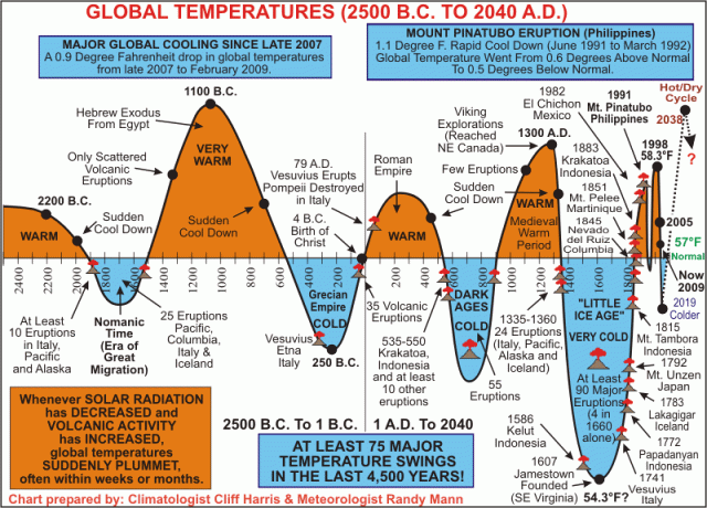
Climate, Volcanoes and History
Oh, gee, there was a big hot mountain and then it dropped into a cold bit for the Greek era. (I note in passing that Greece was founded by Ionians and Dorians migrating southward in a hurry… wonder if they were running away from the encroaching cold further north?). So let’s see, it was hotter, and the water was much higher in the pass, then it got colder, and the water dropped, but now the water is farther away, but it’s because sedimentation has overwhelmed all our spectacular heat?
“I don’t think so, Tim… ”
It looks to me like folks are just not accounting for the actual changes of historical temperatures very well. Sure some of it, maybe even most of it, is sedimentation (a bit of core sampling would be in order, IMHO, to get real data on prior floor level). But just as clearly, the pre-historic runs back and forth of the shoreline are not due to humans. My speculation would be that our “run up” from that deep cold bucket of the Little Ice Age is in fact not as high as we think (or that chart plots).
Here’s an interesting map from the wiki:
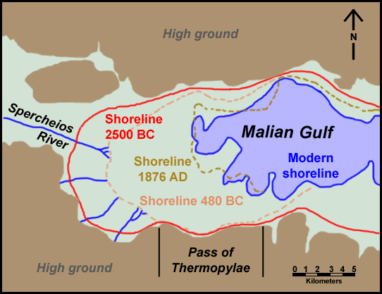
Thermopylae and Malian Gulf shoreline
So shorelines move 10 or 15 km all on their own naturally. This means it’s my fault if it moves a foot just how again? Shorelines are living dynamic things. Most often sedimentation moves shorelines outward. Sometimes it moves inward. Mostly it wobbles back and forth in about the same areas, as attested by lots of erosion features both above and below present shorelines globally. The quest for a fixed immobile shoreline is folly of the tilting at windmills kind.

Isn’t it 2016 + 480 = 2496 interval?
Your math correct? I think you didn’t minus a minus. Should be 2496 years ago.
Sea level is measured, quite accurately these days, by satellites. Perhaps you should devote some of your boundless energies looking at something that doesn’t simply confirm your biases.
https://climate.nasa.gov/vital-signs/sea-level/
But surely you’ve looked at this before. Why ignore it?
Or you could look at an important historical sea level marker cut into rock 150 years ago after a period of detailed record keeping which shows almost no sea level change over that period.
http://morningmail.org/isle-of-the-dead/
@Serioso says:
Wow, since 1993? That’s gotta be climate.
“Earth’s surface gained … 173,000 km2 of land over the past 30 years, including 20,135 km2 of water and 33,700 km2 of land in coastal areas.”
Funny that we have more coastal land than 30 years ago.
http://www.nature.com/nclimate/journal/v6/n9/full/nclimate3111.html
There are many reasons to question the veracity or accuracy of satellite measurements, especially when they diverge from global geo-stationary tide guages which show about 1.48 mm per year.
However I think some miss the message in the article, the .3 mm year assumption for ocean basin sinking makes many assumptions about that, as well as perhaps no assumptions on sentiment inflow into oceans, and local shore lines can change very dramatically regardless of SL rise.
That has been one of my major problems with the assertion that sea level rise is due to thermal expansion of the ocean volume. We have no data on the actual changes in the ocean basin volume (ie the bathtub all that water is sitting in). If the basin volume is changing (sedimentation, volcanic intrusion at the ocean ridges being primary culprits) you can have sea level change with no change in the oceans average temperature and actual water volume. Add subsidence and uplift changing the crustal shape both due to crustal rebound from the ice age unloading and shore line subsidence as we stack billions of tons of concrete and steel on the coastal cities surface and you get a very complex picture that makes it nearly impossible to determine the true cause of a sea level change when you throw in issues like wind flow changes in ocean surface profile as trade winds stack up water against coast lines and other causes.
Even if the sea surface height is actually changing it might not be due to any change in the absolute ocean volume when you consider all those other issues.
Since we have essentially zero data on deep sea volcanic activity and the volume of magma extruded at ocean ridges and mineral build up at hot chimney smokers the “scientists” have to be pretty much shooting in the dark until they get another century or two of high precision data to work with and finish with high resolution sea floor mapping so they can even determine if the basin volume is changing. If Mammoth volcanic dome and yellow stone routinely bulge and subside due to magma movements, who is to say how much random bulging of sea floor is taking place when we have no way to measure it?
@RalphB:
Yup, my bad. That whole BC thing ;-)
Fixed it. Thanks.
@Serioso:
Looking at A does not imply never looking at B. Basic logic. You ought to try it some time. So yeah, I’ve looked at the modern satellite stuff. Loads of issues in it, but most of them abstruse and many minor. A fudge number for subsidence is a big issue though, then the question of “Against what benchmark is it calibrated?” as land moves too. So a lot of time to work out what’s going on in the real world. It also has exactly zero to do with long time scopes. Since this posting is about long time scopes, the satellites are irrelevant.
So, since you have looked at the NASA satellite data, why don’t you try looking at something other than what confirms your bias. Things like Ostia Antica and Thermopylae (and Alviso and the Phoenician docks in north Africa and the landlocked ancient ports at the tip of Sinai and…).
See, that’s the flaw in your pedantic debate tactic, it’s easy to apply symmetrically…
Now, since the whole point of the article is to show sea levels bounce around all by themselves, AND were higher in the past during a hot spike; it is kind of useless to look at a couple of decades of satellite records and try to conclude much beyond the fact that they might have figured out how to calibrate them, maybe, and maybe are working out the impact of different average wind speeds and waves in different climate regimes (AMO / PDO / etc.); or not…
What is quite clear is sea level was much higher a few thousand years ago and has gone down since then at Thermopylae. So was it hotter then with less ice? Kind of like history seems to say? (Confirming the “hotter gives sea level rise”, BTW…) or is sea level disjoint from hotter?
BTW, I have no position between those two. So can’t have a “bias” about it. I think the bulk of data indicate it was hotter then, but the actual sea level changes are a complex intersection of things (as the sedimentation at Thermopylae shows) and I can’t say which ones win and lose the race.
@Tom0mason:
Yeah, strange that, eh?
Really, though, it isn’t all that strange. Folks are very busy filling in shallows all over the place. San Francisco Bay used to be about 2 x as large as now. Boston harbor used to be bigger too and a significant island when Europeans first landed is now part of the land mass ashore… Then add in all the alluvial deposits from nature.
However, were we having any significant sea level rise, that number very much ought to be negative…
@Larry:
Don’t forget that the ocean bottom rose about 9 m during the Indonesia quake / tidal wave.
https://en.wikipedia.org/wiki/2004_Indian_Ocean_earthquake_and_tsunami
Now that was a sharp change so we noticed, but the ocean bottom is a thin pliable membrane over the mantle due to the aspect ratio of it. About 7.5 km thick. Yet the Pacific is about 15,000 km x 19,000 km. That’s a very thin skin. It can rise, fall, buckle and shift easily. All sorts of features are found underwater that had to get there by the land dropping (see Port Of Alexandria where we know if fell in a quake) and more are found above water with sediment deposits. (New Zealand has both, IIRC).
So the whole shape of the bottom is in flux (crustal tides, anyone?)
https://en.wikipedia.org/wiki/Oceanic_crust
Anyone who thinks satellites tell you ocean volume change has no clue about geology.
Seas have been rising since we came out of that last Ice Age, rising seas
in history – not anecdotal – it’s real. Tasmania joined to Great Southern Land
cut off from mainland some ten thousand years ago, Likewise Dogger-land,
some inhabitants head west, ‘Hello Britain,’ some east, ‘ ancient ancestors of
today’s EU, not so lucky, but hey, that’s destiny!
http://ngm.nationalgeographic.com/2012/12/doggerland/spinney-text
The rise in sea level at the beginning of the interglacial was significant in all data. Since then, the “rise” is a massaged number that has to be extrapolated, but basically amounts to nothing since, as we see at Thermopylae, there is crust rising, sediment, mixed with oceans maybe rising. In other words, nothing of much interest has occurred.
Unless you have an agenda, and are looking for data to support a pre-conceived conclusion.
The question is not “is the planet warming”, but is the warming run-away? And dangerous? Neither question begets an answer that is conducive to the hysteria of the movement (religion) of CAGW.
But then that is merely the means to their end.
Off the subject… Canary’s are getting hot again… lots and lots of tremors
@John Howard:
Yeah, I saw that:
https://www.iceagenow.info/canary-islands-40-earthquakes-48-hours-trigger-fears-eruption/
but better discussed in a W.O.O.D. posting or put in “Tips”.
@BethTheSerf:
True. What I find fascinating, though, isn’t the general prolonged rise. It’s the “wobbles”. The usual graph shows a single line with data points each side. IMHO, that’s wrong. It ought to be a wiggly line connecting them. Things surge up, then down, then up again. We see that in the rocks. Like that 2500 BC shoreline in the graph above. It had shot up, then dropped into the 1800s, now might be rising a bit again. We don’t allow enough for the variable nature of “sea level”.
As far as I can tell your links almost always reveal a confirmatory bias, which is why I read them, to counter my own. I trust you sometimes read material with which you disagree. Or perhaps not; I haven’t seen the evidence.
There was a saying, not so long ago, that “You are what you eat,” which I’ve always regarded as garbage: Literally true but completely absurd. But I’ve come to realize that we human being are what we read. And watching TV, however many channels, is far too inefficient a way to absorb information. YOU read too narrowly. You are at the mercy of your biases. Which is why I follow you. Thank you for being my antidote, my source of biased ‘information.’ It’s very beneficial to understand how intellectually curious autodidacts go off the tracks.
There’s a history of autodidacts going off the track…
Galileo Galilei,
We write to inform you,
the science is settled,
your trial starts tomorrow.
Signed,
The Inquisition.
Any wonder there are wobbles, EM? So many inter-acting systems,
sun-spots, solar winds, clouds, volcanoes, equatorial trade winds,
ocean currents, moist air, dry air, radiation, convection, it’s enuff
to make a serf hyper-ventilate, no wonder we have see-saw whether.
The Mediterranian is utterly hopeless for extracting any information about global sea level. It is the site of collision of the Eurasian, Anatolian, African and Iberian plates. To quote Jimmy Reed:
“I’m goin’ up
I’m goin’ down
I’m goin’ up, down, down, up
Anyway ya wanna let it roll
Yeah, yeah, yeah”
Also, the great European Empires destroyed their forests, denuding mountains of trees and soil when they built their navys. All those triremes etc. used a lot of timber, and the soil washed off the naked mountains and filled their ports with sediment.
I live in Tohoku. After the Tohoku Earthquake, all of the ports and harbours on the east coast subsided by about 1 metre. That subsidence took less than a minute. The earthquake was very scary. The first arrival nearly threw me out of my chair, and it was hard to stand.
@Serioso:
What a load of crap. I used Wikipedia fer cryin’ out loud. Biased? Yes, but to the warmers side.
Not seen evidence of me reading warmers positions? Then your eyes are shut. Any time I’ve posted a counter point to a warmers position it means I’ve seen that position, by definition.
Per general news sources, I have no fixed reading list unlike you who push the Left Wing Indoctrination driven New York Times. When a topic comes up, I issue a search on two different search engines, then browse the first couple of pages of links, pick 3 or 4 articles and read them. I don’t look at the source until after that (as it comes up in the header). That is why pretty much the only “regular” source I link is Wikipedia and everything else changes.
So I’ve read, and linked to, sources as diverse as papers from the UK, Australia, India (several), Israel, France, Russia, and many more.
Oh,, and per video being too inefficient: Visual bandwith vastly exceeds verbal. SEEING the actual war activities FROM BOTH SIDES (RT and Al Jazeera tend to be on opposite sides from each other and the USA) gives more accuracy and precision than any words on paper. Reuters has a nice 30 minute round the world coverage (though they are very biased anti-Trump and pro globalism). Then CBS is similar for domestic. In about an hour over morning coffee, I’ve toured the world, SEEN IT FOR MYSELF, and have a good idea what the Left Wing Talking Points are for the day. (Do note that Fox is not in that list. Haven’t been since the move to cord cutting)
Over lunch, I’ll cycle Sky, France24, and a random depending on hot topics (like the local Las Vegas station via ROKU recently). Note that done this way, my hands and mouth are free for meals and I double use the time… now that’s efficient.
Per “you are what you read”: only for folks like you who never learned critical reading and thinking skills. I read The Communist Manifesto every few years, but I’m not a Communist. Read Mein Kampf, but not a National Socialist. I’ve read the Koran, but I’m not Muslim. Your thesis is demonstrably false crap.
BTW, I’ve often stated the importance of “opposition reasearch”. It can only he done by exploring your oppositions works. That’s why I read every line of code in GIStemp AND the publicly available climate models. You can’t get closer to the ground truth of what the authors belive than that. I’ve sunk years into reading their stuff (and have GBytes of PDFs of their papers on my computer for the occasional “lite reading”.
; sarc/ (in case you didn’t pick up on the irony of your claim vs the truth…)
You have no idea what I read, and never will, even when I tell you.
What you don’t like is that I DO read it critically, so don’t get sucked in by it. Spin, propaganda, and fraud are wasted on me. I’ve spent years defending against phising, SPAM, and more, and that hones the senses for BS detection. (Companies pay for that as it is part of computer security operations)
@Seth:
Yes. But that is the point. It is that way globally. Thus the mention of Boston, S.F., Indonesia, and others. The whole ocean bowl is a wobbly bucking thing on geologic time scales. Hawaii is pushing up a new island. Already thousands of feet high to reach the surface, while the old ones slough into the sea… California rises regularly, but The Grand Canyon washed into a spreading zone and Death Valley would be 7000 feet below sea level but for erosion filling it.
The UK is rising on one end and sinking on the other, Iceland is growing and splitting spreading in the process. India whacked into Asia pushing up giant mountains from seafloor. The Great Rift Valley in Africa is hiving off a great chunk and once the cut reaches the ocean the huge below sea level bit will become a huge sea instead, There are salt mines of evaporated sea water in the inland ares of Africa, the USA, and Europe as all of them once were seas, now land. The whole Mediterranean has dried out and refilled a few times.
Yet the panty pissers want to worry my stove is going to melt Antarctica, a place so cold you face freezes in summer. Just lunacy.
@Beth:
Sometimes it does look like TPTB want to return to censors and the inquisition….
Just call me Bruno .
History of European civilization since 2nd or 3rd millenium BC has been heavily driven by the successive waves of invasion from Eurasian horse people of the Russian steppes, they frequently displaced fringing non-nomadic neighbouring populations putting pressure on them to invade the easier-to-beat southerners.
And the satellites measure the level of the sea with respect to what static datum?
Serioso … lets keep up this line of logic and see where it gets us.
Like E.M. I have been reading the warmer talking papers since the SST ozone studies (1971), the Club or Rome “Limits to growth” (1972),TTAPS study (1983), and Stephen Schneider wrote the “Genesis Strategy” (1976) where he predicted we would most certainly be diving into an ice age soon as in the long run historically the world has been significantly colder that the current interglacial warming episode for much of the last 2.6 million years. Throw in Rachel Carson and Silent Spring (1962) and I have been reading the left’s doom and gloom predictions for about 55 years now.
I thought it was true for about 10 years. After the first decade or so I figured out they were full of bull and were world class shoddy scientists selling an agenda not doing science. Since that time not a single prediction that they have made has panned out. They have consistently ignored the scientific historical record (except Stephen Schneider until it became politically inconvenient to notice that global temperatures have gone through ice ages about every 100,000 years for millennia often times while CO2 levels were significantly higher than current levels without any run away heating occurring. The warming episodes always only last about 11,000 -12,000 years or so then drop into deep subzero temperatures where a warm day gets up to single digit negative temperatures outside the tropics.
Confirmation bias does not mean what you apparently think it does.
Confirmation bias is the tendency to interpret ambiguous information always to satisfy existing beliefs.
What you are labeling confirmation bias is the scientific method.
The systematic intentional construction of proofs of a hypothesis derived from a fair analysis of observation and available data that supports that hypothesis.
The hypothesis must be stated in a manner that it can be falsified by an experiment that violates the logical assumptions and conditions of the hypothesis.
The CO2 causes global warming and it is humanities fault hypothesis has been demonstrated to be faulty on dozens of grounds. It is not a fact, it is a faulty theory. We are just pointing out the various cases where that theory and its hypothesis fail various tests.
@Larry:
Ah, yes. Silent Spring. Read it. Believed it. About 5? years later had a class “The Economics of Ecology” where we studied “The Limits To Growth”. The Prof. was genius. Had us spend the first half of the quarter reading and lapping it up, then the last half handed out a reading list of critiques. By the end of it, I’d learned to think critically… I’d thought I was good at it before, but he showed us how to really do it.
When you find you were snookered, the message sticks.
(Symbolic logic class after that also added some tools and an appreciation for consistent syllogisms. Then several computer programming classes topped it up with strict grammar and forced consistent usage.)
Oh, and you left out old Paul Ehrlich and his “We are all DOOMED if anyone has a child” Population Bomb always wrong predictions. Yes, I remember the days in the ’70s when I first read that kind of stuff and “bought it”. Then learned to analyze and see the faults. Then decades past and it was obviously garbage in that NOTHING was close to what they predicted.
But yeah. What I do is find evidence that shows how the DOOM!! folks are full of it and their stuff is a crock. Some of it is obscure science heavy stuff. But my favorites are simple “existence proofs”. Things like a bay where it was much higher water in the past, much lower now, and people had nothing to do with it. Nature is like that.
So someone says “This cures warts”. I look for folks who put it on their warts. When you find many who still have the damn wart, well, pointing that out isn’t “confirmation bias”. It’s observation.
I was very disturbed by the Population Bomb at the time. Now, I’m much more disturbed by Paul Ehrlich.
Latest satellite sea level data, shows sea level has been stable and slowly declining since late 2015. A very significant departure from the coastal tide gauge sea level trend data since 1870.
https://climate.nasa.gov/vital-signs/sea-level/
Pingback: The Peculiar Greek Roots Of Modern Conflict | Musings from the Chiefio