

Lead time of insolation energy over temperatures
This graph from TheInconvenientSkeptic bothers me.
It bothers me because of what it says.
What it says, by two different modes of reading, is that we have no business being warm right now…
OK, I spend a lot of time looking at graphs trying to predict what behaviour comes next out of chaotic time series. Seeing what is a valid leading indicator, and what’s a bogus one. Seeing when there’s a ‘disconnect’ and figuring out what is likely to come next.
So here we have a nice smooth W/m^2 ‘up north’ graph. It has that nice shape because that’s what the orbital mechanics do to the sunshine ‘up north’. See this graph, the black line. It’s basically that last little ‘wobble up’ before the vertical line of where we are now:
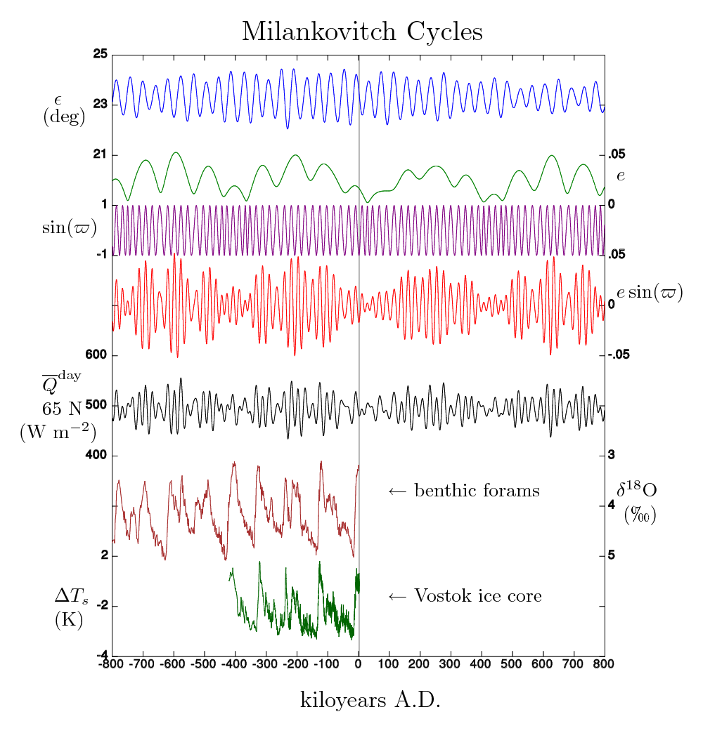
Orbital Parameters and resultant W/m2 N.H.
Now, look at that first graph. Once W/m^2 get above about 440, we start to get some temperature rise. Now we are under 430 (about 428…) The inflection in energy comes about 2 time bars ( 6,000 years ) before the rise kicks in but its a little off page so may be more than two, The inflection to the downside happened about 2+ to 3 time bars ago (about 8,000 to 9,000 years ago). On both ‘inflection’ and ‘Watts level” values, we’re into the ‘any time now’ range.
Both the Greenland and the Antarctica temperatures are lower than their peaks. They are generally trending downward overall. Antarctica in particular lead on the way up, and is lower than Greenland now. Furthermore, we know that right now ice is accumulating in Antarctica. Greenland is the tail on the Antarctic dog… And our W/m2 line is continuing in a decent downward slope. Harder to see in that Milankovitch Cycles composite graph. ( Inspecting it, I was hoping we were already AT the bottom. We are not.) So we have a bit more drop in W/m2 before we start back up, and we are below the energy level that pulls us out of a glacial, once one begins.
All in all, this graph tells me that we are on the knife edge of a drop into a cold stage and acceleration into a glacial stage, from which we can not recover. (This is, in some ways, just a confirmation of the 416 W/m2 or so number from prior plunges – but on a graph showing that our drop in W/m2 is not yet done dropping.)
So if we are very lucky, and do not have a major volcanic event, nor have a nuclear winter, nor have a rock fall from space in size, nor any other cooling event that causes multi-year ice to start collecting near the north pole, we can maybe stay warm. But if an ‘aw shit’ happens, we fall into a non-recoverable decent into the next glacial. We can only exit a glacial when there is sufficient energy to prevent multiyear ice from accumulating at the North Pole. We are presently out of that realm for a large ice pack. Essentially, once the Arctic freezes and does not melt for a few years, we’re done.
This map of the present ocean state / temperature anomaly, shows a cold global ocean. Especially the northern oceans:

Unisys sea surface temperature anomaly graph
(This is a live map from: http://weather.unisys.com/surface/sfc_daily.php?plot=ssa&inv=0&t=cur so will change over time.)
That cold water is about to make the Arctic colder, right as the sun has reduced heating and ice is forming earlier and stronger than the last several years.

Hudson Bay Ice Extent various years
Original Image from IceAgeNow.info.
One can only hope that the present Solar Grand Minimum is not sufficient cause.
“But hope is not a strategy. -E.M.Smith”
Addendum
It looks like, during a very cold glacial, CO2 levels plunge to plant starvation levels and plants don’t grow as well…
http://biblioteca.universia.net/ficha.do?id=912067
Atmospheric CO2 concentration ranged between 180 and 220 ppm. […] indicating that glacial trees were undergoing carbon starvation.[…] we found evidence that C3 primary productivity was greatly diminished in southern California during the last glacial period.
So once it gets very cold, and the cold rain / arctic snow CO2 scrubbers kick in, the food production gets cut too. Along with the fire wood.
Oh dear…

Guess they were right after all, last time http://newsbusters.org/blogs/noel-sheppard/2007/09/19/nasa-scientists-predicted-new-ice-age-1971#ixzz29VXyv4N0
http://motls.blogspot.com/2010/07/in-defense-of-milankovitch-by-gerard.html
This says that using the derivative of ice volume vs insolation on the N.Pole says it’s a damn fine match… which makes that declining solar value 60N all the more troubling…
Will we have the courage to crop dust the Artic ice with carbon black to absorb rather than reflect more of the meger 416 W/m2 ?
I think the signs are not good, we are slipping into a cooling period, we are due a major Icelandic volcanic event, Katla maybe [is just about due] but recent world volcanic activity coupled with a fast refreezing Arctic – it’s all vexing – big comet coming next year a portent of bad tidings maybe.
If I have read it correctly the right hand side of that Milankovitch graph is rather worrying taking everything together.
St Petersburg Times, Jan 1, 1979:
Prediction: Warming trend until year 2000, then very cold.
http://news.google.com/newspapers?id=aJpjAAAAIBAJ&sjid=N3wDAAAAIBAJ&pg=6824,139587&dq=global+warming&hl=en
The maximum activity of the sun was back in 1997-1998, now the future (and something magnetic on 2024):
http://www.vukcevic.talktalk.net/LFC2.htm
@sabertoothed:
Yeah, that was the same Hansen, but then he was selling “Aerosols will cause an ice age and CO2 is a wimp.” Since pollution control came on strongly and sucked down aerosols dramatically, he changed his tune … but still wants the money…
@Kramer:
Nice article (took me a minute to realize I could use the ‘hand grab’ cursor to slide the page around…). Yeah, Engineers. Leads me to think they have it right. That there predictions have been ‘exactly right’ for 30+ years is a good sign too ;-)
@Edward:
Well, the good bit is that an Ice Age Glacial is a very slow thing and takes 100,000 years for the full build-up of ice. So even if it starts yesterday, the ice sheet only advances an average of about 800 feet per year.
The bad news is that the cold can have onset in a couple of decades and the winter snow et. al. can cause dramatic crop reductions fairly fast. That typically leads to a collapse of countries and governments (even empires) and a chaotic collapse of civilizations ( even classical great empires with firm control mechanisms; like the Romans and the Greeks and the Egyptian Empire).
Probably the best I can offer is just that Europe gets the worst of it (and maybe Russia / Canada too) while the entire Southern Hemisphere has a lot less problems. Western USA gets some added drought, but not frozen, and central USA has a similar pattern. So a shift to more drought tolerant crops, stop feeding food to cars, maybe have more meatless meals, and we can get through it all OK (while starting a massive building campaign for nuclear power plants and greenhouses…) Brazil and Australia ought to become very popular places ;-)
But as you pointed out, the real “Aw Shit” is if something like Katla or Krakatao decide to let loose…
@Ian W:
Yes, we’ve been in a period of ‘ringing down’ of the black line. Lower and lower perturbations. That ends, and we go back into a realm of greater swings. That we’ve not yet reached the bottom of this particular downturn (red arc top graph) is a worry, but it is heading to an inflection upward. IFF we can avoid a drop to glacial prior to that upturn, we can likely get another couple of thousand years of warm out of things (as we start up that tiny ‘bump’ just to the right of the vertical ‘you are here’ line). Make that, the next down blip isn’t for about 4-6 kyrs (by eye) though it looks low enough that we ought to go glacial just from that. However, if we can find a way through that one too, we’ve got a good 60,000 years or so until that “you ARE having a glacial” downtick whacks us. (That all, of course, requires no OTHER major cold push, like a Katla, or a large rock from space, that are all very unlikely to hold off for thousands of years…)
After that point, we’re back into the wide swings of insolation 65N and guaranteed ice age glacials with only sporadic very short interglacials spaced out about 100,000 years each.
The only really good news on that very long term POV is that our lives are incredibly short in comparison. The ice builds up slowly, and the oceans drop giving us ever more land along all the worlds shorlines (and there are a lot of shorelines…) So Florida ends up about 2 x as wide as it is now. The UK rejoins Europe and gains the land around it presently under water. Even the places off the Indus Valley in India where they found a city under several hundred feet of water end up back as ‘dry land’. Since that takes 100,000 years, all told (see the Vostock ice ramp) it will be 1000 to 2000 lifetimes. That’s about 3 lifetimes per foot of ocean drop… Just like we didn’t notice the last several thousand years of sea level rise, we won’t notice the drop. And just like our oldest known languages are a few thousand years (and often incomprehensible to modern speakers of ‘the same’ language) the people who have to deal with the problem (if it really is a problem) will be some other culture speaking some other language.
Frankly, I worry more about the 1500 year Bond Cycle than the 100,000 year ice age cycle. It has the potential to move us farther, faster, and give us things like a ‘Year with out a summer” and crop failures over all of Europe ala L.I.A. Things that happen in decades or years, not centuries. So what’s more ‘a worry’ is that it’s about time for a Bond Event / D.O. Event cycle change… That a bad one of them might end up with us ‘locked in’ to a decent into a glacial is interesting ( i.e. we don’t managed to avoid the drop on this down blip of the black line) but the onset of those issues is so slow they will belong to some generation 1000 years from now. (After the next Bond Event, we warm up again over the next 1500 years. So a L.I.A. like excursion for 200 years or so, then a warming like the Modern Optimum, but not as warm… maybe back to about what it was like in 1850. Life was not horrible in 1850… then things wobble even colder in the NEXT 1500 year downturn, perhaps like ‘the year without a summer’ for several years / decades. That will be bad. But by then folks will likely have migrated to Brazil, or be using personal nuclear power plants, or just be watching it all from the O’Neal Space Colonies…. while they harvest the genetic modified Ice Corn in Siberia ;-)
It’s important to think in geologic time ;-)
Not good, the Norse had what? 9 levels of hell, each colder than the last?
We are going to die :), its just a question of when.
Cold seasons and the resulting poverty will have a way of focussing society.
So its back to the solar mirrors in orbit and mini-nuclear devices just for survival?
Or public panic and massive thinning of the herd?
London Calling by The Clash?
Nuclear desalinization Plants in Australia and Sahara?
Geologists keep saying cold=dry for climate.
I have the answer, reenergize the sun, by firing human sacrifices into it.
All eco-warrior volunteers(army style) of course.
I realize the mass of a normal human is magnificently insignificant, but the inflated egos from the current cult must count for something. Some kind of darker energy?
Sarcasm of course but colder is not good and I was promised global warming by my govt,they actually exceeded the IPCC claims and published statements of causation between CO2 emissions and local warming. So legalistically I could insist they owe me the warming I was promised.
The Gerard Roe paper is frustrating. He does good work and demonstrates an interesting degree of match for past times, but lacks the courage to extend it into the future and produce a projection. His paper is thus pointless and useless.
More about Libby and Pandolfi’s forecast from 1979 by Steve Goddard:
http://stevengoddard.wordpress.com/2011/06/01/libby-and-pandolfi-were-correct/
EM,
It concerns me when people advocate meatless meals. Here on the High Plains, we are ideally suited for the raising of meat animals. We have had mama cows who produce a calf year after year and have never had grain at all. They are pastured on grass and if the weather gets so bad that the grass is inaccesible, they are fed hay. We can grow grass, which includes wheat, even if there is limited moisture. Corn, for the most part( although there is a little dry land corn grown here) needs to be irrigated in our dry part of the country. Soybeans, certainly, need higher humidity and rain levels. On the other hand, greenhouses require a lot more water and intensive management. If we look back a few hundred years, the Great Plains were home to millions of buffalo, antelope, elk and other hooved animals. We are windy, treeless, and sparsely populated. If we look at what makes sense, the Plains should stay as a meat producing area, and the more densely populated areas, with water and an available work force, should concentrate on growing crops. With proper management, we could have it all. We just have to keep the government out of it. Yeah, right.
I don’t know why we only ever see 65N wiggles, which don’t really show a clear pattern. Maybe we can get a clearer pattern from some other latitude, say 40N.
The Oceans are a thermal flywheel. There are also several things to consider. During the previous glacial maximum, the rotational pole would have been about where the northern coast of Ellesmere Island is. As all the water migrated from ocean to land, the change in mass distribution would change where the rotational pole is located. We could also get rather amazing (relatively speaking) changes in the location of that rotational pole after things such as huge breakouts of water from behind ice dams. For example, that pole shifted by some extent when lakes Missoula, Agassiz, and Bonneville empties. Those events took a large amount of weight from North America and redistributed it globally. If you look at a graph of sea level rise out of the last glacial, at about the time of Missoula, Agassiz and Bonneville emptying, you find Meltwater Pulse 1A. That would have been a rather huge redistribution of mass that would have moved the rotational pole more toward its current position. Rotationally speaking, when Chicago was under 5000 feet of ice, it was 500 miles farther north than it is today. For Bonneville alone we are talking the release of most of the lake in 1 year and 1000 cubic miles of water in only a few weeks. Missoula held about half as much water but it emptied and refilled about 40 times in a 2000 year period meaning overall it released about 20x as much water as Bonneville. Agassiz was larger than all of the current Great Lakes combined and was simply huge and was about the size of the Black Sea and it filled/drained at least twice. One draining alone probably raised global sea levels over 2.5 meters and may be responsible for the 8.2ky event when the final ice blocking Hudson Bay from the Arctic Ocean gave way. An earlier draining of that lake might be responsible for the Younger Dryas.
Wow, what I find interesting here: http://calderup.files.wordpress.com/2010/07/ncfig200011.jpg is that it looks like the coming interglacial may be colder than the last one with a “double dip” glacial maximum. Not looking good.
Well, the snow failed to melt in the hills around Anchorage this year which is at about 61N.
@J. Martin:
Well, maybe not completely pointless… it points out what formula to actually use, so others can move to projections / predictions / whatever….
@Judy F:
Please note that I am not advocating for meatless meals. I am describing them as a survival coping strategy. What I’d advocate for, in fact, is to eat as much meat as possible now, since that builds all the grain growing infrastructure and farms to feed all the animals and makes a larger standing stock. Then, if the Aw Shit comes, we have a lot more stock to consume and then a lot more of their feed “if it comes to that”…
Your point on grazers is well taken. Frankly, that’s part of why I started a bunny herd. To have a miniature browsers / grazers portion of my ‘toy farm’. They can eat the things I can’t, and provide fertilizer to boot. (Then I found them rather intelligent and realized I’d not be able to do with them what I happily do with mean pigs and stupid chickens… so I’m looking for a new, preferably mean stupid and ugly, grazer for my ‘toy mini-farm’… Maybe possums or rats or… ;-) I’d use chickens were it not for them waking me, and the neighbors, at sunrise…)
In an ideal world, I’d have miniature Nubian goats ( milk / cheese ) but the spouse says no…
So yes, I’m in the same camp as you: I’m against folks advocating for meatless meals or meatless days now, because it’s exactly the wrong way to prepare for later. (Besides, try as I might when having dinner with vegetarian family and friends, I just can’t see any way to live happily without ham and eggs, hamburgers, leg of lamb, fried chicken, roast turkey, baked salmon…) But, if forced into it by a world ending calamity and faced with otherwise certain extinction, well, OK, I’ll have a ‘meatless Monday’ … for a while… maybe…. as long as fish are not counted as “meat”… or eggs… or the occasional porkchop… ;-)
@J. Martin:
The use of 60 N or 65 N is a direct result of the asymmetry of the planet. It is the sunlight “up north” that melts the Arctic, and that’s all that matters. The Antarctic is too cold to ever melt. The Tropics, well, the sun just wobbles back and forth overhead and it modulates the thunderstorms. It is only the N. Pole that has ice floating on water with land around it. Where the geography allows a hysteresis driven ice cap / no-ice sea. (As it ‘locks up’ in ice, it acts like another Antarctica and ‘never melts’. Then it takes excessive sunshine to melt it, that only happens at an extreme point of the cycles. After that, it acts like open water staying melted… until persistent multi-year ice starts to stay grounded all around and the arctic currents start to be cut off as the water level drops… then it flips back to frozen… Yes, persistent multi year ice and a lower sea level is to be feared, mightily. Yet that is exactly what the ‘always wrong’ AGW folks are demanding to see happen; to save us….)
At any rate, the only light that matters is the modulation ‘up north’…
@Crosspatch:
Don’t forget the filling of the Mediterranean and Black Sea as mass redistributions as well…
Don’t know how they map to glacials…
I’m pretty sure the Younger Dryas was an impact event, into the ice in Canada. See the Cosmic Tusk guys. I think they’ve nailed it.
http://cosmictusk.com/
So; talk about your ‘melt water pulse’… what happens when a multiple square mile hole gets blasted into the ice?!
But yes, once we’re ‘in the soup’ on the next one, we stay in for a long time (until the next big upward pulse) which is why I’d like to stay out as long as possible…
I expect our first indication will be lowering permanent snow caps on mountains globally, but especially toward both poles. The return of the glacier growth of the L.I.A. When that happens, move to the coast somewhere warm. (You will be gaining land as the ocean drops ;-)
I hear Florida is nice ;-)
The good news is that Florida will become absolutely huge. The coasts of the Southeast will eventually expand all the way out to the continental shelf. Australia will connect with Papua New Guinea and Indonesia/Malaysia/Philippines will also become huge areas of land so there will be a lot more tropical land area. Wonder how we will figure out the boundary disputes between places like Florida and the Bahamas. Canada will become uninhabitable. We might as well start making plans to mine it. There will appear a huge chunk of land that might state ice free off the coast of Newfoundland in the area that we now call the Newfoundland Banks. Ocean currents will keep it warmer but the Gulf of Mexico will be greatly reduced in area and the Gulf Stream flow will be reduced as the outlet gets pinched through a smaller channel between Florida and Cuba so the heat transported out of the Gulf will be a lot less. The Mississippi and Missouri will become more seasonal flows, probably all but drying up and freezing over in winter. New Orleans will be many miles inland. It will take many thousands of years for all that land to appear, though.
When the next melt occurs, the center of the US will be an absolute quagmire for a few thousand years as all that ice melts. We’ll be picking up bits of Winnipeg from the fields of Nebraska for a while.
We are likely to get some warning in that we should see Northern Hemisphere summer snow cover begin to exceed normal climatology. Lately we have seen just the opposite. While *winter* snow cover has exceeded climatology, the last 5 years or so have seen summer snow cover below average. The notion that we stated into the current glaciation agrees well with information from alpine valleys in Europe. We are seeing wood at the terminal moraines of these glaciers that carbon dates to about 5kya. That would mean that the valleys that are currently glaciated were forested up to about that time. Of course we will see periods of warming and cooling as things such as solar cycles modify climate but we see over particularly the past 3000 years a series of warm and cool periods where each cool period is cooler than the previous. The LIA being the longest cold period in the Holocene and at its peak was likely colder than the 8.2ky event but was certainly longer in duration. We have still not recovered as there are still known mines in the Alps that were working before the LIA that are still iced over and productive fields in Scandinavia (and Greenland) where it is still impossible to farm.
If I were the Canadian government, I would start making plans right now to mine as much as possible out of the northernmost parts of the country. Same goes for the US with regard to the North Slope and this might have something also to do with Russia’s keen interest suddenly in developing Arctic mineral resources — those might not be available to us for very much longer. Even a slight cooling from today’s temperatures can make a larger amount of difference in areas above the arctic circle.
@EM,
FYI, it is only roosters that crow in the morning. Hens do not crow, but chickens of any kind tear up a garden terribly. ( They keep down the bug problem, but they scratch up the dirt and small plants.) Although you can raise chickens “free range”, I would certainly keep them confined if they were in a rather small yard. This might give you some ideas. http://fancybuilder.blogspot.com/
One of my sons used to raise rabbits for both show and meat. It was difficult to tell people or think about the fact that the bunnies were going to be slaughtered. It was easier to say that they were going to the Bunny Nugget factory. I know, semantics. Goats actually make a lot of sense, as they can be used for meat and milk.. However, they eat everything, including pine trees and rose bushes. It was hard to garden around my house, with all the critters about.
I should have included :) after the chicken coop pictures.
@Crosspatch:
You bring up an interesting point….
Part of WHY the arctic stays melted now is the thermohaline circulation of the Gulf Stream delivering all that Gulf heat to Scandinavia and the Arctic…. so as The Gulf shrinks and shallows and the ‘exit’ cuts off to the north…. what are the odds that reduction in heat collector area and heat transport is part of the ‘lock up’ into an ice age glacial non-melting ice cap in the Arctic?
I can not remember seeing that put forward as part of the mechanism. They talk about reduction in the THC but due to where the cold salty bit sinks, not due to smaller collector and ‘weak stream’
;-)
@Judy F:
I had two “hens” once in my back yard (the ones that lay the ‘easter egg’ colored eggs’ ;-) and, well, turns out the folks doing the ‘sexing’ got one wrong… So I was surprised one morning by one of the ‘young hens’ starting to crow….
When in college, we had a few hens in a pen in the back corner of the yard. Mostly just tossed scraps in and some scratch and feed. In an “urban farm” they need a pen or the local cats, well, they have a ball… We’d occasionally let them out to ‘work over’ the garden after harvest…
My only problem with hens, really, is that I’ve had to pluck birds (pheasants)… Really don’t like it. Especially wet pick…
I refuse to have a chicken coop that looks better than MY house!
;-)
I’ve thought of trying Guinea Hens… and I’m pretty sure that I’d be fine with pigeons. They can be big:
https://en.wikipedia.org/wiki/Viti_Levu_Giant_Pigeon
But the only really big pigeon still around is about the size of a small chicken…
At any rate, I’ll think of something… (but it can’t be cute of fluffy… or talk to me…. ;-)
If only there were vegetarian alligators…
If the CAGW folks turn out to be wrong they won’t be handing back any of the billions they received. Don’t hold your breath waiting for an apology or an admission of error.
They will simply ask for even more billions to study CAGC.
A good smith is worth his weight in gold and you are worrying about raising food! Let real farmers and stockmen worry about food production. Do what you are best at and trade. Hell, even a good cook is hard to find. pg
I have read that during the last glacial winter the Gulf Stream moved to the south and entered the Mediterranean sea/Spain area but I do not know where I read it from but I think it was based on evidence.
By the way you might find this science paper worth reading:
Is the Gulf Stream responsible for Europe’s mild winters?
Click to access Seager_etal_QJ_2002.pdf
Mr. Seagers Columbia University website:
http://www.ldeo.columbia.edu/res/div/ocp/gs/
One other thing I read was a study that showed during the last glacial we seemed to have a persistent La Nina condition in the equatorial Pacific. That actually makes a lot of sense when you consider that winds are generally a heat transport mechanism. While insolation changes at high latitude, equatorial insolation is more a factor of orbital eccentricity. Wobble in the tilt of the axis can change summer insolation at 65N by a great deal but it will not change equatorial insolation even a little bit. What this does is sets up a change in the difference in energy received by the high latitudes and the low latitudes that varies over time. When that difference is greatest, one would expect (I think) to see stronger winds related to the distribution of that energy so the Earth either tries to pump more energy up North to reach equilibrium or failing that, the energy gets stored in the equatorial region and it gets warmer.
A la nina condition is basically when we have stronger trade winds that cause upwelling off the coast of South America causing cooler surface water temperatures. But it is also a time of generally less cloud cover. So while the surface of the central equatorial Pacific is cooler, there is a net energy GAIN from the sun. This energy gets shoved over into the Western Pacific and the creation of a Western Pacific Warm Pool. What is interesting about all of that is a study I read from some folks at Woods Hole that seemed to show that water temperatures in the Caribbean went UP during the LIA. Stronger trades would act on the Atlantic in somewhat the same way as in the Pacific where they would push warmer water into the Caribbean and Gulf of Mexico. There would be less clouds so there is more solar energy being collected by the ocean but the increased wind shear reduces the formation of large tropical storms and drought conditions are common in the equatorial land masses. In fact, in the equatorial rain forests of South America, the rainfall would no longer support the forests and it became a central belt of savannah with two belts of rain forest father to the north and south along the ITCZ. But all of this points to an increase in accumulated energy in the tropics, an increase in wind shear that inhibits formation of large tropical storms, a decrease in heat transport to the poles due to land masses causing a serious change in how sea currents flow today to move that equatorial heat to the poles.
Look at this map: http://www.iceagenow.com/Sea_Level_During_Last_Ice_Age.htm
The Indian Ocean becomes nearly completely cut off from the Western Pacific except for a relatively shallow area which is more visible in this map where everything in “pink” is pretty much land during an ice age glacial maximum: http://www.ngdc.noaa.gov/mgg/image/global_topo_large.gif
That might be another reason why we bound OUT of glacial events so quickly. Once ice starts to melt and ocean level begins to rise, more avenues for heat to leak out of the tropical oceans appear and the rest of the oceans begin to warm up through this increased circulation. If you think of the equatorial region as the engine and the high latitude ocean as the radiator, we find during the ice ages a situation where the water pump speeds up but the radiator hose gets pinched off and when that pinch is finally released, the radiator gets hot quickly.
I would be willing to bet that during glacial periods, what is now dry tropical and sub-tropical desert such as in Mexico and the Southwestern US are absolutely raging with storms because of a larger difference in temperatures to the north and south of that region.
@Sunsettommy:
Take a look at:
and keyword search on Florida.
The Gulf Stream slows down and leaves more of the heat in the Gulf, so Florida stays warm, and gets bigger. So next Ice Age Glacial, Florida is the place to be (and maybe Texas, Louisiana, Alabama, Mississippi, Georgia… )
As per the paper: It’s interesting, but he’s looking at things as they stand now. During an ice age glacial there’s a different dynamic. That ocean heat he’s talking about is replaced with a layer of sea ice. Also, the Gulf Stream turns downward into the thermohaline sink at a different place. So take away the Gulf Stream and you get Arctic Ice and then that ocean heat can’t warm Europe…
@GallopingCamel:
IMHO, Hansen has already done that flop once. He started off proclaiming a new ice age was on the way in the ’70s…
@P.G.Sharrow:
The problem is that I’m an “OK smith”… While I’d likely get the skills up pretty fast and I do know the basics, it’s not something I could survive on ‘day one’. Also there will be a large standing stock of metal goods for a few years. That means I likely need to feed myself for a few years as I build a smithy and all. (First make a pig iron cast hammer and anvil. Harden them. Then use them to forge the tooling to make a final forged hammer and a proper anvil. Then use them to make the rest of the tooling for the shop and then make a better bellows and furnace. Then you can start to do ‘work for hire’ in size… Takes a while. Traditionally a Smith traveled with his anvil and hammer. You could make the rest fairly fast… Without them, it was a bit of a boot strap problem. If you couldn’t make the iron hot enough to cast, you could use a lump of iron as a crude anvil and a softer metal hammer to make a first iron hammer. But that chews up a lot of bronze… Then again, I’ve got a 4 lb sledge in the garage already and a chunk of RR Track makes a decent anvil and I know where there are abandoned tracks.)
But frankly, I think the easier path will just be selling my Rustica tobacco. Smokers will find a way to trade beans for smokes… I don’t have much dirt, so need the max bang per square foot. That’s tobacco, IMHO. And not just for smoking. Tobacco tea as a natural insecticide will be worth a lot to folks. The Rustica has a higher level of nicotine than most (it’s usually used in chew or in hybrids to raise nicotine levels); again to maximize dirt production.
Being basically lazy, it’s a lot easier to trade someone a brick of dried tobacco for a 1/2 cord of wood for the forge than to chop the trees myself… besides, then I can sell them the axe head too ;-)
Yeah, ‘drug dealer’ ;-) Makes even more money than the smith… and with less work…
Of course, I’m hoping it never gets anywhere near that bad and all this is just a ‘fun fantasy’ of preparation pondering.
@Crosspatch:
Interesting POV. Now I’ve got some more things to “Dig Here!” on. Ice age storm levels / evidence.
I think generally your description is right. It matches the Florida example, but on a global scale. We know total energy flux stays nearly constant, so other than some higher albedo up north, the southern and middle oceans are absorbing as much as ever (more, really, since fewer W/m2 are going N of 65N). So more in, and less polar transport, ought to be more tropical storms and rains. Would explain why the tropical plants are not ‘frost hardy’. It never, ever, gets that cold there, even in a glacial.
So a glacial isn’t so much a ‘cold time’ as a ‘less heat transport’ time… Hmmm….. Means Texas ought to be nice ;-) and California too… ( IFF we have any water…)
Key might be in speleothem forensics.
http://www.sciencedaily.com/releases/2010/01/100120161243.htm
Thinking about it another way … if the ocean currents are unable to equalize the heat, the atmosphere will take over that function to a greater degree than today.
So if the Kuroshio current and Gulf Stream reduce their heat transport through a reduction in access to warm water, I would look for a more active Hadley cell to take over the job.
I haven’t read this paper yet but it seems to be the one mentioned in the article: http://www.geo.arizona.edu/~reiners/geos474-574/Wagneretal2010.pdf
E.M.Smith says:
30 December 2012 at 12:13 am
….. I’d use chickens were it not for them waking me, and the neighbors, at sunrise…
>>>>>>>>>>>>>>>>>>>>>>>>>>>>
It is the roosters that crow at sunrise not chickens… HMMMmmmm, I wonder if anyone has ever tried hooding a rooster the way you do a falcon. photo or you could use a blackout sheet on his cage.
How to stop your rooster crowing – maybe
If you do try chickens (no roo just for the eggs) I recommend the Dominiques They are a heritage breed, dual purpose meat & eggs with a nice personality and calm. Rhode Islands Reds are down right nasty and Silkies are real sweeties.
As far as cooling trend goes I think we are headed into it already. The CAGW clowns have mucked up the temperature record to the point we have no idea of what the real trend is. All we have is the satellite data.
Arctic- length of melt season – graph The melt season is getting shorter the last five years (Solar cycle 24)
Shortening of the N. Hemisphere summer seems to have started N.H. October Snow Cover graph
From those two graphs it looks like we are on the down hill side of the peak.
The other piece of information was the Bi-polar seesaw and the end of the interglacial. WUWT covered the paper.
I really do not care if it gets a bit warmer. Despite all the teeth gnashing it really is no problem. What is a problem is Cold and Dry. THAT I want to know about and I sure hope our governments prepare for it.
Unfortunately the idiots in the US government decided to get rid of the US strategic grain reserve so the speculators like Goldman Sachs and the grain traders like Cargill could reap record profits and the hell with the children they starved.
How Goldman gambled on starvation
Want food security? Bring back a national grain reserve
Corporations are still making a killing from hunger
Unfortunately our politicians are bought and paid for and are not interested in what is good for the country only what is good for their campaign donors Top Senate Democrat: bankers “own” the U.S. Congress, Dick Durbin’s confession…
Also, the northern extent of the Gulf Stream is dependent on where the water finally sinks. Generally, it floats on top of the rest of the ocean as it gets cooler and saltier from evaporation until at some point it sinks to the bottom. When the atmosphere at high latitude cools significantly, it would possibly sink at an earlier point in its travel and this would terminate the surface exposure of gulf heat. So we might not initially be looking so much at a “shutting down” of the Gulf Stream so much as an earlier sinking of it into the deep Atlantic. It’s salinity at the point of sinking would also be different so that could change the entire dynamics of deep ocean circulation. Once sea levels have dropped enough to expose the Newfoundland Banks we might see the Gulf Stream deflected east toward Europe at a much lower latitude where from my reckoning it would make a bee line toward the Azores and might not sink at all. It would just become an Atlantic analog to the North Pacific Gyre where it evolves into a circular current. This would shut the NADW off and might, in turn, be responsible for why the deep waters of the South Pacific go stagnant during the glacials and sit for tens of thousands of years on the bottom without being flushed. So this evolution of the Gulf Stream from a current that sinks into the abysmal deep to a North Atlantic gyre might just disrupt the entire global ocean circulation and ventilation pattern.
There would still be SOME NADW but it would consist, I speculate, of the much saltier, much colder water from the seasonal brine rejection from sea ice. So you get a denser, saltier, slower NADW that looks nothing like the modern NADW and might just spread out across the abysmal deep more than flow as a “stream” to Antarctica as it does today. It’s all so complex and interdependent, it is going to be interesting for researchers to watch it unfold over the coming millennia.
@Crosspatch:
The paper referenced in the D.O. / see-saw page finds exactly that. During a Glacial, the water sinks south of Iceland and that makes all the difference in the world. The ice cap stabilizes and becomes permanent.
So generally I think you are correct about the overall mechanism. It’s all ocean current moderated mode changing. That’s also why, IMHO, the lunar tidal 1500-1800 year cycles can have so much impact. It isn’t just “random ocean oscillations” as a lot of folks describe it. It is externally modulated ocean current changes. Even just the difference depth of the tides as the moon shifts from further north to further south over the decades changes the total water depth and volume at high and low tides. ( A more detailed version of my speculation about Drake Passage).
I guess it’s a bit of a ‘good news / bad news’ thing. It says we can modulate the climate to keep things essentially as they are by modulating ocean currents and depth. But how to do that is, er, a bit problematic. The ocean is a very big place….
Other than cutting a trench across Panama with nukes, I doubt we could do much that would change things. Dump ‘fill’ in Drake Passage and it will just wash away. Dredge anywhere on the ocean bottom, it’s a nano-scale scratch… Heck, I’m not even sure we could make a bit enough channel through Panama to influence the main currents. I expect it would take many km of width and a km of depth.
Which all basically says we’re at the mercy of the lunar orbital changes and the earth orbital changes. With a tiny little “Solar Kicker” as it has it’s oscillations of warmer / colder in the longer term glacial / interglacial cycle. That also implies that things like mirrors in space are not going to ‘cut it’ and that putting soot on the ice up north will just give you dirty snow under the next snowfall…
Oh Dear. Don’t like where that leads… ;-)
The “scale” of things is just too large for ideas like adding salt to the arctic waters to increase the rate of turnover to make any kind of dent at all. At most, you buy a tiny bit of time, but one modest shift of the larger driver undoes everything and then some. We don’t have a way to direct where the Gulf Stream goes and how big it is…. And it is only one of several…
One the plus side, thanks for the paper! So we can put the “Desert Southwest” on the ‘keepers’ list as they start getting more water. Nice. Very nice. Maybe I’ll buy that “worthless chunk of desert scrub” near El Paso after all ;-)
I think the moon has less to do with it and wind has more. The Gulf Stream is generally win driven by the Bermuda High. It is the 9 o’clock side of that clockwise circulation. Replace that high with a low and the Gulf Stream cuts of … completely. Or just move it a bit East and it moves much father out into the ocean while dragging cold Arctic air down over Europe. The North Pacific is basically the same and the currents are driven by the wind. In this paper you find the notion that the winter time Aleutian Low stays year-round off the west coast of North America and the winter storms we experience now are then allowed to happen year-round. What would have happened is that the reduced insolation results in more snow surviving summer melt in the Western mountains and this begins to spread down into the plains. The weight of the ice begins to push the mountains down. This also results in mantle material being pushed south, by the way, and is a possible reason for the activation of some volcanism in the Southwestern US during the late Pleistocene. But anyway, this pushing down of the mountains allows these coastal storms deeper access into the continental landmass. In particular the paper mentions a “saddle region of the Rocky Mountains between 54N and the St. Elias range” that was depressed some 2000 to 3000 feet by the weight of ice and allowed storms to pass with more water to the interior. So a lot of this may be a sort of domino effect where a buildup of ice changes temperatures over large areas which changes weather patterns which pumps in more snow that enables even more moisture, etc.
Interesting paper so far: http://earth.geology.yale.edu/~ajs/1945A/1.pdf
Actually, it doesn’t look like the last glacial period was all that bad in California. The Tahoe and Tioga glaciations of Yosemite never saw the glacier make it out of the valley, got about as far as Bridalveil Meadow. The glaciation that filled Yosemite to the rim was some six glacials ago though this next one is (if the data in the posting is any indication) to be about 50% longer and much colder than the last one was so we are likely to see deeper glaciation in the valley. The most obvious consequence would be an increase in central valley flooding and the conversion of the central valley into a vast inland lake/swamp if the winter cyclones come ashore all year round.
I believe that “saddle” area might be found if you draw a line from Summit Lake airport North of Prince George BC to Tumbler Ridge airport on the other side of the ridge line. Looks like you can get through the rockies there without going over 5000 feet between Sentinel Peak and Mount Vreeland.
Looks like its getting dangerous to hold these views!
http://www.americanthinker.com/2012/12/professor_calls_for_death_penalty_for_climate_change_deniers.html
” I expect it would take many km of width and a km of depth. “ Re widening the Panama canal. Facing 100,000 years of glaciation I reckon it could be done.
Your graph at the top. Shift the red line two bars to the right and you get a better match, but one that still says temperatures are should be heading South very soon. No idea what mechanism can provide a 6000 year buffer though. Or are we looking at the wrong curve, what’s needed is an insolation curve that matches the green / blue line, work out the theory afterwords.
I doubt that excavating the Panama would solve that problem and may make it worse. We are already well within the temperature range needed for iceover of the far north. All we need is heavier snows in the winter. Glaciation is caused by excessive snows, not by excessive cold. I once lived in the glacier area of Alaska and it is relatively warm, barely below freezing even in the depths of winter. But it snows all the time, wet heavy snow that accumulates as ice. The areas that are cold, get light snows that sublimate or directly evaporate without accumulation.
The iceover will start with heavy snow that lasts well into the spring and reduces the spring warmup and melt. Think of the BTUs of energy needed to cause air warming verses the BTUs needed to melt icy snow.. It takes months of strong sun to melt 5 Feet of Sierra Cement! 20 feet will last all summer in the California mountains. pg
Ok, the place to keep an eye on is Athabasca glacier in the Columbia snowfield in British Columbia, Canada. When you begin to hear reports that Athabasca glacier is advancing, that will be our cue to start mining the daylights out of the Alberta tar sands.
The thing is ablation over time and a lot of that has to do with precipitation amount and timing along with cloud cover and probably less to do with air temperature.
What you need is a net accumulation of snow in one year that is greater than the net ablation. There are many things that can change the rate of ablation. A change in the timing of precipitation can do it. For example, if the storms bring the winter precip are early, they fall as rain. A significant rainstorm can cause a rather large amount of ablation. A summer that is cloudier than usual can retard the normal summer ablation. A dry winter can result in less added mass so the following summer ablation is greater than the winter snow pack. I read a paper concerning glacial advance/retreat in the Italian alps and flows on the Po river a few years ago. The conclusion was that greatest ablation happened when precipitation changed from being mostly snow to being mostly rain. So while the net annual precipitation didn’t change, the nature of that precipitation did. A degree or two of temperature change might not melt that much snow in and of itself but if as a result of that change one or two storms early or late in the season are rain rather than snow, it causes a significant change in ablation for that year.
We saw such a thing in California in the late 1990’s when we had a significant snow pack and then suddenly got a “pineapple express” that raised snow levels to over 6000 feet. The resulting rains washed away most of that snow and Manteca was under water for several days.
By the way, first snow in this hills around Anchorage came about a month early this fall.
Athabasca Glacier, 1906 vs. 1998
Click to access 004844ar.pdf
@crosspatch says:”By the way, first snow in this hills around Anchorage came about a month early this fall.”
And I understand that the Portage Glacier, near Anchorage, has been growing the last few years. When I lived nearby, back in the mid 1970s, it had been shrinking for over 30 years and many experts claimed that it would be extinct by 2000. pg
Shasta glaciers have been growing, as well.
As well as the permanent snow fields of the east side of the Warner Mountains in northeastern California. When I was young in the early 1960s they disappeared. By the early of the 2000s they had begun to reappear. pg
Another data point in support of drought in Southwestern US when the Northern Hemisphere climate is warm: Relict nebkhas (pimple mounds) record prolonged late Holocene drought in the forested region of south-central United States
http://www.sciencedirect.com/science/article/pii/S0033589409000040
I can’t find a copy of the paper that isn’t behind a paywall but happen to have the issue of Quaternary Research that includes the paper. Basically these “pimple mounds” in Oklahoma and Arkansas (they exist elsewhere, too, but those were the areas studied) are small windblown dunes that probably grew up around some woody shrub during periods of the Holocene where the areas experienced what we would today call “mega drought”. These periods were about 6800 years ago would would have been during the Holocene Optimum and another where they saw various periods of accretion of existing mounts between 1600-2300ya (that would be the Roman warm period and another brief unnamed warming just after the post RWP cooling) and another from 1100ya – 700ya which would correspond roughly with the MWP.
This is an interesting comment on Athabasca glacier in Columbia, Canada.
Pingback: The age old battle of the thermostat – the ‘Goredian’ Knot of global temperature | Watts Up With That?
I’d like to see the first graph extended prior to 21,000 BP. I suspect it would be a flat mirror image of recent trend.
I believe the previous interglacial was shorter but had a higher peak than this one. Right now we are in a period of nearly circular orbit and it is becoming less eccentric over the next 50,000 years or so: http://www.jgiesen.de/kepler/eccentricity1.html (see the graph near the bottom). The “worst” time is when we have a very eccentric orbit and the south pole points at the sun in summer. This gives the South pole about 9% more radiation than now and the North pole about 8% less. The South pole will stay glaciated and reflect more sunlight to space, the North pole will see much less energy absorbed by the Arctic Ocean.
@Michael A. Lewis:
It’s squashed together, and in two lines, but the ‘first graph’ from ancient times is represented in a way in the Malenkovich graph. The temperatures are the Benthic Forams line and the Vostok line while the summer energy is the black oddly wiggling line that is made from compositing the other individual effects.
About 120 k years ago we had a spike in temps and summer energy that caused the Eemian interglacial, then energy ‘rings down’ as temperatures and ice wander back into glacial conditions. Recently (geologically…) at 10 kya we had another spike, thus this interglacial, and we’re now starting the ‘ring down’ on energy…
@Gail:
Gee…. 700 years ago it was about as warm as now, eh? Snicker ;-)
@Crosspatch:
Nice one. So plains droughts as indicators of the ‘cycling down’ of warmth…. Repeated cycles, but each one a bit less warm and a bit less drought.
@P.G.:
They have a name, or just search on Warner Mountains snow fields?
@J. Martin:
It takes time to overturn the whole ocean, and it takes time to melt a mile thick layer of ice… So put a block of ice in a pan on the stove, turn it on low heat. Slowly advance the heat to medium low over 10 minutes. Ice isn’t all melted yet…
@Crospatch:
But what causes the winds to shift?…. I think the causality runs from lunar / tidal and solar, to water flows, to winds, to surface waters, to weather… but it needs dissecting and evidence…
I believe it is the trade winds and the cycle of El Nino and La Nina. If you head over to Bob Tisdale’s website, he has posted a video as part of his preliminary December sea surface temperature posting. The action of El Nino and La Nina acts as a “pump”. During a La Nina condition the Western Pacific Warm Pool is basically “overcharged” with warm water blown across the Pacific. La Nina, while it reduces sea surface temperatures actually increases the energy content of the Pacific Ocean. When the trade winds relax (El Nino), this warm pool “sloshes” back across the equatorial Pacific and dumps heat into the atmosphere. So here we see atmospheric heating but a reduction in net energy in the ocean itself because that heat is being dumped. The interesting part happens when that El Nino ends and the trade winds return. We then see Rossby waves begin to return warm water AT DEPTH (important) back to the Western Pacific. This water then hits the east coast of Asia it begins to curl north where it ends up around the area of Japan and out into the North Pacific as a warm anomaly. So in this way that energy that gets created during La Nina gets redistributed during the El Nino after El Nino gets pumped into the higher latitudes.
I have found evidence in a couple of papers that during the last glacial, there is evidence of a persistent La Nina condition or at least during the glacial maximum period. In other words, that action that pumps warm water into the North Pacific stops and it seems to go to persistent La Nina. One reason for this might be a change as sea level drops between Australia and Indonesia as that area begins to emerge from the ocean it likely becomes very warm and convective. This could act to “pull” the trade winds across the Pacific and strengthen them (while possibly at the same time reducing or reversing the trades in the Indian ocean). In any case, we start to lose a lot of the mixing with the Indian Ocean and the Pacific. Without the El Ninos, we don’t see so much pumping of the equatorial heat into the North Pacific.
Now at first I thought about looking for papers that describe the behavior of winters during La Nina years but I then realized that was wrong because when we experience a La Nina condition in these times, we are often (though not always) also redistributing the water from a previous El Nino condition. We last experienced a strong El Nino in the 2009-2010 period and as you can see by sea surface temperature charts, the warm anomaly in the central North Pacific has about shot its wad. It is now down to under a degree and a half warmer than normal and is nearly completely surrounded by water 2 degrees cooler than normal and Nino-3.4 is back in negative territory but we basically have a neutral ENSO condition. The pumping of the tropical moisture nearly due North that we see right now is similar to what we saw last year during the La Nina condition we had at that time but it HAS been broken a couple of times by outbursts sweeping down from the Gulf of Alaska like we might have coming down right now. Last year that pattern didn’t get broken much until late in the season.
In any case, the cause of the winds to shift is ultimately changes in location of temperature differences and convection. Exactly HOW these winds shift during such periods is rather unknown as we have never had a period of prolonged La Nina conditions while we have had the ability to make large scale observations of weather over the entire ocean so it is all speculative at this point. How would things look if we went 20 years without an El Nino? No idea, because we haven’t gone 20 years without one since at least 1950. The longest durations without one were in the middle 1950’s and another in the early 1960’s. I have data for periods before that but no graphs, I’ll have to build one, I suppose.
Then there is a possibility, if Svensmark is correct, that how things behave under La Nina could change during periods of grand solar minima. For example, if a weak sun results in an increase in clouds, then the La Nina doesn’t “charge” the Western Pacific Warm Pool to the extent that it does during periods of a more active sun so that could also change the whole dynamics of how the system works during periods of differing levels of solar activity depending on the amount of cloudiness.
@EMSmith; No names for the Warner Mountain snowfields. The Warners are a tilted up lift ridge that is very steep on the eastern, leeward side. Generally 8,000 to 10,000 feet elevation and located in the northeast corner of California. Wind driven snows fill in the north facing canyon headlands with deep snow that sometimes lasts for years. Surprise Valley below is irrigated from the snow melt of the Warners on their east side and the Pit River to the west, that feeds the Sacramento River at Shasta Lake. pg
@P.G.: Thanks!
@Crosspatch:
Don’t forget that UV goes to depth in the ocean while IR stops at the surface. The “Hot Sun” does more heating at depth. The “Sleepy Sun” has the heating more at the surface, so goes directly into evaporation and leaves. I have no idea what ‘size’ it is, but that ought to cause more need for ‘overturning’ in “Hot Sun” times and more rain / cooling in “Sleepy Sun” times.
Basically the same total energy shifts from ocean mediated distribution to wind driven distribution… to an unknown size…
IMHO, the method by which we get 19 year lunar cycle matching and longer cycle lunar cycle matching weather changes is the way tides change. Take the Southern Current. It whacks into Drake Passage, and a cold shot goes up the spine of S. America then spreads out into the Mid Pacific. Now make Drake Passage 20 foot shallower (ice cap forming) or 3 feet deeper (high high thigh tide on strong lunar cycles). In one case you get more cold water shooting up to the central Pacific. In the other case, a lot less. Something similar happens on the Atlantic side. The “jet” out the “nozzle” of Drake Passage causes the South Atlantic Gyre to rotate. More flow makes a faster rotate, less flow makes a lesser rotate. So a shallow Drake Passage would give colder Pacific and slower rotating Atlantic (that sucks heat out of the Indian Ocean that gets it from the Pacific that…) So that ought to give a colder A. America side and a hotter Asia side. That differential then drives winds…
That’s the hypothesis, anyway. “Needs work”, I know ;-)
Overall, Alaska cooled 2.4 degrees F since 2000.
http://www.alaskadispatch.com/article/forget-global-warming-alaska-headed-ice-age
Looking through a few papers … notice that the Bermuda High did diminish during the last glacial. One of the hallmarks of the very end of the glacial and the early Holocene are a reduction in the strength of the continental high pressure over the ice sheet and a corresponding increase in the Bermuda High and weakening of the Aleutian Low (with a strengthening of the Western Pacific High). This could very well have reactivated or at least enhanced the movement of the Gulf Stream. As the Bermuda High begins to strengthen, it begins to pull more water up the East coast of the US through wind action.
Weather must have been really bad in the midwestern US, particularly during spring and fall when the weather was changing between winter and summer regimes. At the period of maximum solar insolation, temperatures in the Southeastern US were up to 6 degrees warmer than today in summer. Winter temperatures were colder than today during most of the early Holocene was the air came across what remained of the ice sheet. Winter temperatures were colder than present up until only about 6kya.
Now I see why the Mammoths in North America went extinct … they were all struck by lightning! There must have been some absolutely brutal storms when warm Gulf of Mexico air was pulled up into and mixed with the dry cold air coming off the ice sheet, even when the forward edge of it had retreated well up into Canada. We probably have never witnessed storms of the magnitude that were common at that time in the spring. The temperature difference between winter and summer in places like Oklahoma and Kansas must have been absolutely amazing. They probably had three seasons: Cold, Mud, and Hot and it probably transitioned quickly from Hot to Cold in the fall.
@EM Smith: Start reading this at page 121 for about three pages or so, I think you will find it interesting:
http://books.google.com/books?id=mj-hgKfzIzsC&pg=PA122&lpg=PA122&dq=bermuda+high+glacial&source=bl&ots=9cQG6Zjxy2&sig=fk7Alw4dWcHLjpqEfsChoxQ8oCc&hl=en&sa=X&ei=O9DjUKyLA4fY2QXO7IDIBA&ved=0CEcQ6AEwAg#v=onepage&q=bermuda%20high%20glacial&f=false
I am thinking of buying the book. It’s about $160 though:
I believe that the idea of the solar/lunar tides act as the west to east pressure pump and the winds act to modulate the circulation is the concept to examine in depth. The tides are not just rise and fall of local water but water being dragged toward the east from the west as the earth rotates to the west. At Panama this can cause quite a difference in tide levels from coast to coast. pg
If you are considering raising chickens in an urban setting, a large breed like Rhode Islands or some others are worth considering because once grown, they have no trouble explaing to cats that cats are merely cats and should stay away for their own good. They’ll also catch and kill (and eat) mice and small rats – rather gruesome but it not only keeps the rodents down, the rattlesnakes stay away since there isn’t much prey. Many people would find larger breeds aggressive and they are, but humans are bigger and can comvince even the stupidest of RI roosters that we’re too big to take on. We had _really_ free range RI and other very-large-breed chickens on my parents’ ranch and never lost any to coyotes, cats or other predators. Allowed to browse on grass, seeds, insect larvae, insects and the occasional unwary rodent, they – and their eggs – are far more flavorful than any store-bought chicken, even those laughingly referred to as “free range.” They are nominally, but only nominally. Country chicken is as flavorful as turkey.
Pingback: Interesting Cosmic Rays Paper | Musings from the Chiefio
Pingback: Lunar Cycles, more than one… | Musings from the Chiefio
{ Judy F. says:
29 December 2012 at 8:48 pm }
I wonder what Yak tastes like. Buffalo or chicken? ;<)
E.M.
Obama's election—continued erosion of freedom–Al-J piped into America–impending ice-age??
You're depressin me man!!
Also, I’ve been to Banff, Alberta. Athabasca Glacier is in Alberta.
Odd.
My calculations for available direct and indirect sunlight at each day of the year for latitudes greater than 60 degrees show that the recent record-high Antarctic Sea Ice maximums in mid-September at the equinox reflected a significant amount of sunlight, which (all else being equal) will cool the planet. Antarctic sea ice was 1 million sq km larger than any previously recorded at 15.5 million km^2; the nominal “edge” of the Antarctic sea ice was between 61 and 62 degrees south latitude. (Antarctic land ice covers a rough near-permanent “circle” from the South Pole down to latitude 72 south. This Antarctic sea ice forms a “crown” around the continent every year, disappearing to near-nothing at all locations except the ice shelves.. The very large permanent Antarctic sea ice shelves cover water, or extend out over what eould be water if the shelves didn’t rest on the shallow seas and bays, but they don’t melt yearly, and did not “break off” or “float” away this season.)
However, at the same time that the Antarctic sea ice was setting record highs, the Arctic sea ice was setting record low sea ice extents. Unfortunately, my calculations show that – at the latitude of the actual Arctic sea ice at minimum extents, at the time of those minimum sea ice extents in mid-September, there is not enough solar energy being absorbed by the newly exposed water to heat anything else. Looking at each square meter of newly exposed water in more detail, I’m calculating the reverse effect: “Each newly exposed area of Arctic Ocean in September at the time of minimum sea ice extents loses more energy through radiation, evaporation, and conduction than it gains from absorbing solar energy. The more Arctic sea ice loss, the greater the loss of energy from the water.”
Now, since this is exactly opposite of what “conventional Arctic amplification” by the CAGW theory believes, I’d like to present each equation, the spreadsheet for each day at each latitude, the solar data (from NOAA) and the references here, and see where the error lies. Humbly, I’d like to feel that “conventional wisdom” is correct, that I’ve missed something and Arctic sea ice loss truly does create positive temperature feedbacks that will catastrophically end up heating the Arctic even moer.
Somehow, I doubt it, but I’m skeptical. What I suspect is that “conventional Arctic amplification” is correct, but only at certain latitudes at certain days of the year. Melting Arctic sea ice does heat the planet, but ONLY at few limited days of the year at ONLY a few specific latitudes bands. The rest of the year, as the sun crosses ever lower in the sky for ever shorter periods each day, the net heat exchange reverses, and increased sea ice melting increases heat loss into space through radiation, into the atmosphere by evaporation and conduction.
Worse case, if the increasing Antarctic sea ice maximums, decreasing Arctic sea ice minimums are cooling the planet, are a source of what J. Curry believes are increasing snow and ice levels across the northern land areas this winter, and are “feeding” increasingly negative temperatures globally, then we may indeed have reached a Hansen-Mann “tipping point” … The wrong way.
Pingback: AGW – What will the New Year bring us regarding this Pseudo-Science Scam? | The GOLDEN RULE
Pingback: Interesting Change of Season Length | Musings from the Chiefio